IMAGES TAKEN NEAR TO
Manton Lane, BEDFORD, MK41 7NU
Introduction
This page details the photographs taken nearby to Manton Lane, MK41 7NU by members of the Geograph project.
The Geograph project started in 2005 with the aim of publishing, organising and preserving representative images for every square kilometre of Great Britain, Ireland and the Isle of Man.

There are currently over 7.5m images from over14,400 individuals and you can help contribute to the project by visiting https://www.geograph.org.uk
Image Map
Images are licensed for reuse under creativecommons.org/licenses/by-sa/2.0
Notes
- Clicking on the map will re-center to the selected point.
- The higher the marker number, the further away the image location is from the centre of the postcode.
Image Listing (12 Images Found)
Images are licensed for reuse under creativecommons.org/licenses/by-sa/2.0
Image
Details
Distance
5
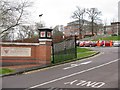
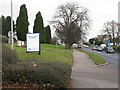
Entrance to Bedford Modern School
On Manton Lane, a large independent school.
Image: © M J Richardson
Taken: 5 Dec 2008
0.13 miles
8
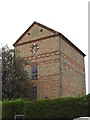
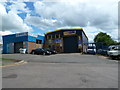
Charles Wells Water Pumping Station
This is the water pumping station in Park Road North that Charles Wells used for water for their brewery when it was in the town. It looks as if it is still in use but I do not know if it is used by the Charles Wells brewery as that is now in Queens Park.
Image: © Melvyn Gibbs
Taken: 24 Nov 2013
0.22 miles