IMAGES TAKEN NEAR TO
The Baulk, BEDFORD, MK41 6HA
Introduction
This page details the photographs taken nearby to The Baulk, MK41 6HA by members of the Geograph project.
The Geograph project started in 2005 with the aim of publishing, organising and preserving representative images for every square kilometre of Great Britain, Ireland and the Isle of Man.

There are currently over 7.5m images from over14,400 individuals and you can help contribute to the project by visiting https://www.geograph.org.uk
Image Map
Images are licensed for reuse under creativecommons.org/licenses/by-sa/2.0
Notes
- Clicking on the map will re-center to the selected point.
- The higher the marker number, the further away the image location is from the centre of the postcode.
Image Listing (9 Images Found)
Images are licensed for reuse under creativecommons.org/licenses/by-sa/2.0
Image
Details
Distance
1
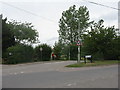
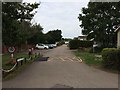
Green Lane and The Baulk
Two cul-de-sac roads on the north side of Clapham, the right hand one leading to Bedford & County Golf Club.
Image: © M J Richardson
Taken: 17 Jun 2011
0.04 miles
2
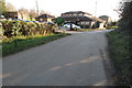
Houses at Clapham Green
On The Baulk, as seen from Clapham Park Farm.
Image: © M J Richardson
Taken: 17 Jun 2011
0.05 miles
5
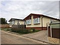
Bedford and County clubhouse on Green Lane
Image: © Philip Jeffrey
Taken: 24 Feb 2019
0.14 miles
6
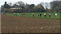
Bedford Clanger
Runners taking part in the Bedford Clanger - 26 mile run around Bedford. At this point the runners are about to approach a checkpoint roughly 12.5 miles into the run.
Image: © Dennis simpson
Taken: 13 Mar 2011
0.14 miles
7
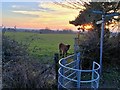
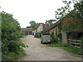
Footpaths and calf at Clapham Park Farm
Image: © Philip Jeffrey
Taken: 24 Feb 2019
0.18 miles
8
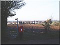
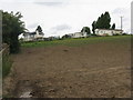
Back of Clapham
Looking over the back of Clapham, from Clapham Green
Image: © Oliver White
Taken: 20 Nov 2005
0.21 miles