IMAGES TAKEN NEAR TO
The Glebe, BEDFORD, MK41 6GL
Introduction
This page details the photographs taken nearby to The Glebe, MK41 6GL by members of the Geograph project.
The Geograph project started in 2005 with the aim of publishing, organising and preserving representative images for every square kilometre of Great Britain, Ireland and the Isle of Man.

There are currently over 7.5m images from over14,400 individuals and you can help contribute to the project by visiting https://www.geograph.org.uk
Image Map
Images are licensed for reuse under creativecommons.org/licenses/by-sa/2.0
Notes
- Clicking on the map will re-center to the selected point.
- The higher the marker number, the further away the image location is from the centre of the postcode.
Image Listing (9 Images Found)
Images are licensed for reuse under creativecommons.org/licenses/by-sa/2.0
Image
Details
Distance
7
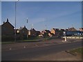
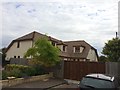
New housing estate
Built in 2005, and still under construction at the time of this photo.
Image: © Oliver White
Taken: 20 Nov 2005
0.16 miles
8
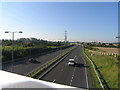
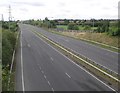
Clapham Bypass, A6, looking south from Oakley Road Bridge
Clapham Bypass was opened in 2002 and named after local runner Paula Radcliffe who had recently won the London and Chicago Marathons, setting a world record time of 2:17:18.
Image: © Keith Rose
Taken: 24 Jul 2007
0.18 miles
9
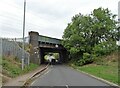
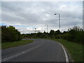
Midland Main Line railway bridge over Oakley Road
Image: © JThomas
Taken: 23 Sep 2022
0.24 miles