IMAGES TAKEN NEAR TO
The Close, BEDFORD, MK41 6DP
Introduction
This page details the photographs taken nearby to The Close, MK41 6DP by members of the Geograph project.
The Geograph project started in 2005 with the aim of publishing, organising and preserving representative images for every square kilometre of Great Britain, Ireland and the Isle of Man.

There are currently over 7.5m images from over14,400 individuals and you can help contribute to the project by visiting https://www.geograph.org.uk
Image Map
Images are licensed for reuse under creativecommons.org/licenses/by-sa/2.0
Notes
- Clicking on the map will re-center to the selected point.
- The higher the marker number, the further away the image location is from the centre of the postcode.
Image Listing (24 Images Found)
Images are licensed for reuse under creativecommons.org/licenses/by-sa/2.0
Image
Details
Distance
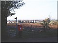
2
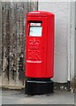
Elizabeth II postbox on High Street
Postbox No. MK41 115.
Image: © JThomas
Taken: 23 Sep 2022
0.08 miles
3
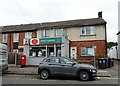
Post Office on High Street
Showing position of Postbox No. MK41 115.
Image: © JThomas
Taken: 23 Sep 2022
0.09 miles
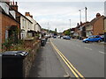
4
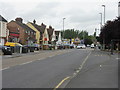
Clapham High Street
Looking west along what was once the A6.
Image: © M J Richardson
Taken: 17 Jun 2011
0.10 miles
7
Back of Clapham
Looking over the back of Clapham, from Clapham Green
Image: © Oliver White
Taken: 20 Nov 2005
0.15 miles
9
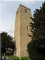
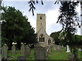
Clapham, Bedfordshire, St Thomas of Canterbury
Image: © Dave Kelly
Taken: 3 Apr 2018
0.15 miles