IMAGES TAKEN NEAR TO
Thor Drive, BEDFORD, MK41 0WN
Introduction
This page details the photographs taken nearby to Thor Drive, MK41 0WN by members of the Geograph project.
The Geograph project started in 2005 with the aim of publishing, organising and preserving representative images for every square kilometre of Great Britain, Ireland and the Isle of Man.

There are currently over 7.5m images from over14,400 individuals and you can help contribute to the project by visiting https://www.geograph.org.uk
Image Map
Images are licensed for reuse under creativecommons.org/licenses/by-sa/2.0
Notes
- Clicking on the map will re-center to the selected point.
- The higher the marker number, the further away the image location is from the centre of the postcode.
Image Listing (13 Images Found)
Images are licensed for reuse under creativecommons.org/licenses/by-sa/2.0
Image
Details
Distance
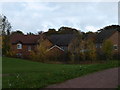
1
Houses on Thor Drive
A newish cul-de-sac development surrounding an open space east of Goldington.
Image: © M J Richardson
Taken: 15 Jun 2011
0.06 miles
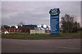
2
The western Edge of Bedford
Edge of a housing development, as title suggests on the Western Edge of Bedford, for now!!
Image: © Dennis simpson
Taken: 7 Nov 2010
0.11 miles
3
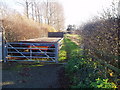
Entrance to bridleway
Bridleway goes over lock, under main road, and joins the bedford-sandy cycleway
Image: © Oliver White
Taken: 2 Dec 2006
0.13 miles
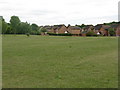
5
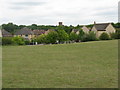
Houses on Thor Drive
Looking north over an open space from the Norse-themed housing estate towards the Crematorium.
Image: © M J Richardson
Taken: 15 Jun 2011
0.15 miles
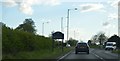
7
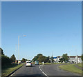
Entering Bedford on the A428 St.Neots Road
Image: © Geographer
Taken: 9 Aug 2014
0.16 miles
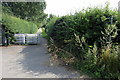
8
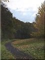
Rain Approaching
Footpath heading south towards the A428
Image: © Dennis simpson
Taken: 7 Nov 2010
0.17 miles