IMAGES TAKEN NEAR TO
Gunnersbury Park, BEDFORD, MK41 0SX
Introduction
This page details the photographs taken nearby to Gunnersbury Park, MK41 0SX by members of the Geograph project.
The Geograph project started in 2005 with the aim of publishing, organising and preserving representative images for every square kilometre of Great Britain, Ireland and the Isle of Man.

There are currently over 7.5m images from over14,400 individuals and you can help contribute to the project by visiting https://www.geograph.org.uk
Image Map
Images are licensed for reuse under creativecommons.org/licenses/by-sa/2.0
Notes
- Clicking on the map will re-center to the selected point.
- The higher the marker number, the further away the image location is from the centre of the postcode.
Image Listing (4 Images Found)
Images are licensed for reuse under creativecommons.org/licenses/by-sa/2.0
Image
Details
Distance
1
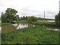
The River Ouse
From the old railway bridge over the river, which now carries the Ouse Valley Way.
Image: © M J Richardson
Taken: 8 Sep 2008
0.18 miles
2
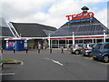
Welcome to TESCO Bedford
Just off the A428 Goldington Road to Cambridge on the eastern outskirts of Bedford.
Image: © M J Richardson
Taken: 23 May 2011
0.21 miles
3
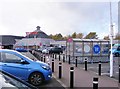
Tesco View
The view near the A428 Goldington Road on the eastern outskirts of Bedford.
Image: © Gordon Griffiths
Taken: 12 Nov 2018
0.22 miles
4
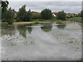
Footpath from the Ouse Valley Way to Goldington
Path across a flooded field after rain.
Image: © M J Richardson
Taken: 8 Sep 2008
0.23 miles