IMAGES TAKEN NEAR TO
Church Close, Church End, BEDFORD, MK41 0NQ
Introduction
This page details the photographs taken nearby to Church Close, Church End, MK41 0NQ by members of the Geograph project.
The Geograph project started in 2005 with the aim of publishing, organising and preserving representative images for every square kilometre of Great Britain, Ireland and the Isle of Man.

There are currently over 7.5m images from over14,400 individuals and you can help contribute to the project by visiting https://www.geograph.org.uk
Image Map
Images are licensed for reuse under creativecommons.org/licenses/by-sa/2.0
Notes
- Clicking on the map will re-center to the selected point.
- The higher the marker number, the further away the image location is from the centre of the postcode.
Image Listing (16 Images Found)
Images are licensed for reuse under creativecommons.org/licenses/by-sa/2.0
Image
Details
Distance
1
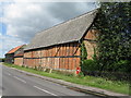
Barns at Renhold
One timberclad, the other brick and timber, with a GR post box, at Tithe Farm.
Image: © M J Richardson
Taken: 20 Jun 2011
0.03 miles
2
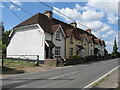
Houses at Renhold
A row of six, one with a monogram 'CHP', another with a date brick '1906'. The CHP is possibly Cecil Henry Polhill [1860-1938] who, after missionary work in China, returned to Britain and inherited the Howbury Hall estate - Howbury Hall is just a kilometre away.
Image: © M J Richardson
Taken: 20 Jun 2011
0.04 miles
3
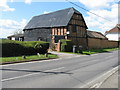
Barn at Tithe Farm
Brick and timber barn, with non-traditional roofing material.
Image: © M J Richardson
Taken: 20 Jun 2011
0.05 miles
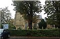
7
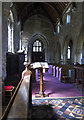
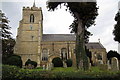
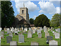
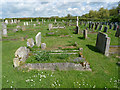
Interior, All Saints Church, Renhold
View looking to the west end of the church.
Image: © Cameraman
Taken: 13 May 2010
0.08 miles
9
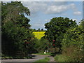
Oilseed rape in flower at Renhold
Looking west towards Salph End. The traffic lights control the narrow bend and bridge crossing a small brook.
Image: © M J Richardson
Taken: 20 Jun 2011
0.15 miles
10
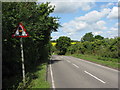
Country road at Renhold
Looking west towards the traffic-light controlled bend and bridge over an unnamed tributary of the Renhold Brook.
Image: © M J Richardson
Taken: 20 Jun 2011
0.15 miles