IMAGES TAKEN NEAR TO
Top End, BEDFORD, MK41 0LR
Introduction
This page details the photographs taken nearby to Top End, MK41 0LR by members of the Geograph project.
The Geograph project started in 2005 with the aim of publishing, organising and preserving representative images for every square kilometre of Great Britain, Ireland and the Isle of Man.

There are currently over 7.5m images from over14,400 individuals and you can help contribute to the project by visiting https://www.geograph.org.uk
Image Map
Images are licensed for reuse under creativecommons.org/licenses/by-sa/2.0
Notes
- Clicking on the map will re-center to the selected point.
- The higher the marker number, the further away the image location is from the centre of the postcode.
Image Listing (9 Images Found)
Images are licensed for reuse under creativecommons.org/licenses/by-sa/2.0
Image
Details
Distance
2
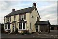
Another dead pub
This one is The Three Horseshoes at Renhold
Image: © Philip Jeffrey
Taken: 23 Sep 2014
0.08 miles
3
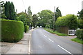
Top end Renhold
Top end Renhold approaching the Three Horseshoes pub.
Image: © Shaun Ferguson
Taken: 31 Aug 2007
0.08 miles
4
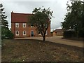
Abandoned looking des res at Church End
Image: © Philip Jeffrey
Taken: 23 Sep 2014
0.12 miles
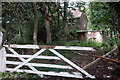
5
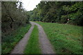
Bridleway to Southend Farm by the Great Early Grove
Image: © Philip Jeffrey
Taken: 23 Sep 2014
0.14 miles
7
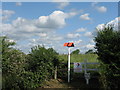
High pressure pipeline marker
Marking the pipeline crossing a country road at Renhold, and going across a field of oilseed rape.
Image: © M J Richardson
Taken: 20 Jun 2011
0.22 miles
8
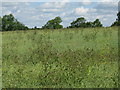
Oilseed rape at Renhold
Flowering is over and the seed is setting in the pods, together with a crop of thistles.
Image: © M J Richardson
Taken: 20 Jun 2011
0.23 miles
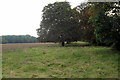
9
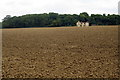
Field by Church End with Great Early Grove beyond
Image: © Philip Jeffrey
Taken: 23 Sep 2014
0.25 miles