IMAGES TAKEN NEAR TO
Green End, BEDFORD, MK41 0LJ
Introduction
This page details the photographs taken nearby to Green End, MK41 0LJ by members of the Geograph project.
The Geograph project started in 2005 with the aim of publishing, organising and preserving representative images for every square kilometre of Great Britain, Ireland and the Isle of Man.

There are currently over 7.5m images from over14,400 individuals and you can help contribute to the project by visiting https://www.geograph.org.uk
Image Map
Images are licensed for reuse under creativecommons.org/licenses/by-sa/2.0
Notes
- Clicking on the map will re-center to the selected point.
- The higher the marker number, the further away the image location is from the centre of the postcode.
Image Listing (11 Images Found)
Images are licensed for reuse under creativecommons.org/licenses/by-sa/2.0
Image
Details
Distance
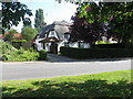
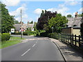
1
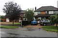
Houses on Water End, Renhold
Without the number I'd have had terrible trouble finding this. The fancy house looked like the one next door in 2012, and has now had new windows and facing, plus a small veranda.
Image: © David Howard
Taken: 4 Oct 2020
0.06 miles
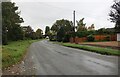
5
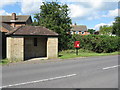
Post box and bus stop at The Green
At the eastern end of the village, also known as Workhouse End.
Image: © M J Richardson
Taken: 20 Jun 2011
0.11 miles
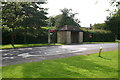
7
White House at Workhouse End
On The Green, at the eastern end of the village.
Image: © M J Richardson
Taken: 20 Jun 2011
0.13 miles
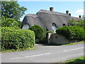
8
Thatched cottage, Green End
Between Brook Farm and Workhouse End at Renhold.
Image: © M J Richardson
Taken: 20 Jun 2011
0.19 miles
9
Thatched houses at Workhouse End
At the eastern end of Renhold Village.
Image: © M J Richardson
Taken: 20 Jun 2011
0.20 miles
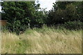
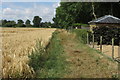
10
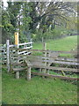
Stile and Bridge on footpath to Workhouse End
A public footpath crosses a drainage ditch heading toward Workhouse End.
Image: © Robert Kerr
Taken: 19 May 2012
0.20 miles