IMAGES TAKEN NEAR TO
Water Lane, BEDFORD, MK41 0JH
Introduction
This page details the photographs taken nearby to Water Lane, MK41 0JH by members of the Geograph project.
The Geograph project started in 2005 with the aim of publishing, organising and preserving representative images for every square kilometre of Great Britain, Ireland and the Isle of Man.

There are currently over 7.5m images from over14,400 individuals and you can help contribute to the project by visiting https://www.geograph.org.uk
Image Map
Images are licensed for reuse under creativecommons.org/licenses/by-sa/2.0
Notes
- Clicking on the map will re-center to the selected point.
- The higher the marker number, the further away the image location is from the centre of the postcode.
Image Listing (6 Images Found)
Images are licensed for reuse under creativecommons.org/licenses/by-sa/2.0
Image
Details
Distance
1
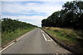
Half of the old St Neots road
Now a single track to a few farms
Image: © Philip Jeffrey
Taken: 8 Aug 2013
0.10 miles
2
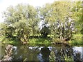
River Great Ouse
Riverside walk near Danish Camp
Image: © James Wood
Taken: 4 Oct 2015
0.13 miles
3
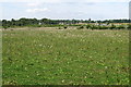
Pasture in front of the Water End interchange
Image: © Philip Jeffrey
Taken: 8 Aug 2013
0.17 miles
4
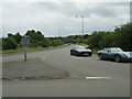
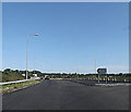
St Neots Road approaching the A421
At the flyover junction with the A421.
Image: © M J Richardson
Taken: 2 Jul 2023
0.19 miles
5
A4280 Water End, Renhold
Approaching the bridge over the A421
Image: © Geographer
Taken: 9 Aug 2014
0.24 miles
6
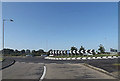
A421 Slip Road at Renhold junction
At the junction with A4280 St Neots Road, and Water End.
Image: © Geographer
Taken: 9 Aug 2014
0.25 miles