IMAGES TAKEN NEAR TO
Abbey Close, BEDFORD, MK41 0JG
Introduction
This page details the photographs taken nearby to Abbey Close, MK41 0JG by members of the Geograph project.
The Geograph project started in 2005 with the aim of publishing, organising and preserving representative images for every square kilometre of Great Britain, Ireland and the Isle of Man.

There are currently over 7.5m images from over14,400 individuals and you can help contribute to the project by visiting https://www.geograph.org.uk
Image Map
Images are licensed for reuse under creativecommons.org/licenses/by-sa/2.0
Notes
- Clicking on the map will re-center to the selected point.
- The higher the marker number, the further away the image location is from the centre of the postcode.
Image Listing (6 Images Found)
Images are licensed for reuse under creativecommons.org/licenses/by-sa/2.0
Image
Details
Distance
1
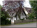
Brook Cottage, Renhold
On the northern edge of the south section of Renhold - on the road which connects the two sections.
Image: © Kokai
Taken: 7 Aug 2005
0.04 miles
2
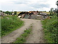
Strange collection of wood at Renhold
Between Ravensden Road and a crop field - not the place for a bonfire, but that is what it looks like it might become. Something very similar is visible on 2-yr-old Google Earth imagery.
Image: © M J Richardson
Taken: 23 Jun 2011
0.13 miles
3
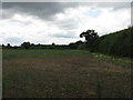
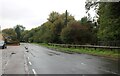
Looking along the hedge
From Ravensden Road, looking over a very poor field of wheat towards Marsh Wood.
Image: © M J Richardson
Taken: 23 Jun 2011
0.16 miles
4
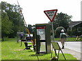
Telephone Box (and signs), Renhold Village
At the junction of the main road through Renhold and a road running west (initially) to Bedford - approx. ref. TL079527.
Image: © Kokai
Taken: 7 Aug 2005
0.21 miles