IMAGES TAKEN NEAR TO
Elliott Crescent, BEDFORD, MK41 0HL
Introduction
This page details the photographs taken nearby to Elliott Crescent, MK41 0HL by members of the Geograph project.
The Geograph project started in 2005 with the aim of publishing, organising and preserving representative images for every square kilometre of Great Britain, Ireland and the Isle of Man.

There are currently over 7.5m images from over14,400 individuals and you can help contribute to the project by visiting https://www.geograph.org.uk
Image Map
Images are licensed for reuse under creativecommons.org/licenses/by-sa/2.0
Notes
- Clicking on the map will re-center to the selected point.
- The higher the marker number, the further away the image location is from the centre of the postcode.
Image Listing (17 Images Found)
Images are licensed for reuse under creativecommons.org/licenses/by-sa/2.0
Image
Details
Distance
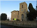
3
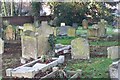
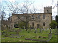
Cemetery at St Mary's
Graveyard of the Parish Church.
Image: © Dennis simpson
Taken: 12 Feb 2008
0.05 miles
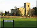
6
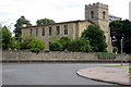
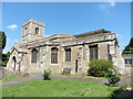
Church at Goldington
The church is dedicated to St Mary the Virgin.
Image: © Carl Jones
Taken: 16 Mar 2007
0.08 miles
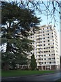
8
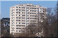
Bury Court
Large block of flats on the outskirts of Bedford.
Image: © Dennis simpson
Taken: 12 Feb 2008
0.11 miles