IMAGES TAKEN NEAR TO
Shuttleworth Road, BEDFORD, MK41 0EP
Introduction
This page details the photographs taken nearby to Shuttleworth Road, MK41 0EP by members of the Geograph project.
The Geograph project started in 2005 with the aim of publishing, organising and preserving representative images for every square kilometre of Great Britain, Ireland and the Isle of Man.

There are currently over 7.5m images from over14,400 individuals and you can help contribute to the project by visiting https://www.geograph.org.uk
Image Map
Images are licensed for reuse under creativecommons.org/licenses/by-sa/2.0
Notes
- Clicking on the map will re-center to the selected point.
- The higher the marker number, the further away the image location is from the centre of the postcode.
Image Listing (13 Images Found)
Images are licensed for reuse under creativecommons.org/licenses/by-sa/2.0
Image
Details
Distance
1
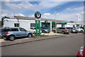
Car dealership on the Elms Farm estate
Image: © Philip Jeffrey
Taken: 8 Aug 2013
0.05 miles
3

Hatters Furniture Store on Goldington Road
Image: © Steve Daniels
Taken: 19 Nov 2011
0.12 miles
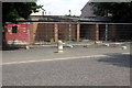
4

Barons bodyshop on St Neots Road, Goldington
Image: © David Howard
Taken: 30 Jan 2022
0.16 miles
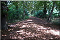
6
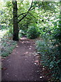
Footpath into the woods by Goldington Green
Image: © Philip Jeffrey
Taken: 8 Aug 2013
0.17 miles
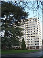
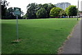
9

Bury Court
Large block of flats on the outskirts of Bedford.
Image: © Dennis simpson
Taken: 12 Feb 2008
0.24 miles
10
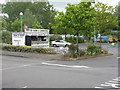
Snack bar at Goldington
Servicing customers at HOMEBASE, Wickes and other outlets at this out-of-town shopping area to the east of Bedford.
Image: © M J Richardson
Taken: 13 Jun 2011
0.24 miles