IMAGES TAKEN NEAR TO
Wingfield Close, BEDFORD, MK40 4PB
Introduction
This page details the photographs taken nearby to Wingfield Close, MK40 4PB by members of the Geograph project.
The Geograph project started in 2005 with the aim of publishing, organising and preserving representative images for every square kilometre of Great Britain, Ireland and the Isle of Man.

There are currently over 7.5m images from over14,400 individuals and you can help contribute to the project by visiting https://www.geograph.org.uk
Image Map
Images are licensed for reuse under creativecommons.org/licenses/by-sa/2.0
Notes
- Clicking on the map will re-center to the selected point.
- The higher the marker number, the further away the image location is from the centre of the postcode.
Image Listing (6 Images Found)
Images are licensed for reuse under creativecommons.org/licenses/by-sa/2.0
Image
Details
Distance
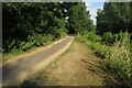
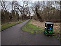
1
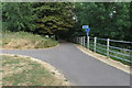
Footpath to Queens Park from the Ouse path
Image: © Philip Jeffrey
Taken: 8 Jul 2018
0.10 miles
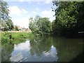
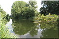
5
Footpath next to the river Ouse, looking west
Image: © Rob Purvis
Taken: 10 Mar 2018
0.24 miles
6
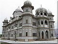
Sikh Temple on Ford End Road
In the Queen's Park area of Bedford.
Image: © M J Richardson
Taken: 24 Jun 2011
0.24 miles