IMAGES TAKEN NEAR TO
Prestwick Road, BEDFORD, MK40 4FH
Introduction
This page details the photographs taken nearby to Prestwick Road, MK40 4FH by members of the Geograph project.
The Geograph project started in 2005 with the aim of publishing, organising and preserving representative images for every square kilometre of Great Britain, Ireland and the Isle of Man.

There are currently over 7.5m images from over14,400 individuals and you can help contribute to the project by visiting https://www.geograph.org.uk
Image Map
Images are licensed for reuse under creativecommons.org/licenses/by-sa/2.0
Notes
- Clicking on the map will re-center to the selected point.
- The higher the marker number, the further away the image location is from the centre of the postcode.
Image Listing (10 Images Found)
Images are licensed for reuse under creativecommons.org/licenses/by-sa/2.0
Image
Details
Distance
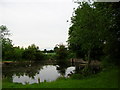
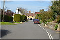
1
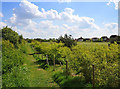
Footpath near Great Denham golf course
The footpath leads to Biddenham village.
Image: © Dr Richard Murray
Taken: 26 Apr 2009
0.13 miles
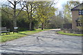
7
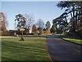
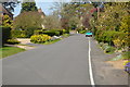
The Grand Entrance to Biddenham Village
Village sign, christmas tree (out of view), war memorial, and general picturesqueness.
Image: © Oliver White
Taken: 11 Dec 2005
0.23 miles