IMAGES TAKEN NEAR TO
Muirfield, BEDFORD, MK40 4FB
Introduction
This page details the photographs taken nearby to Muirfield, MK40 4FB by members of the Geograph project.
The Geograph project started in 2005 with the aim of publishing, organising and preserving representative images for every square kilometre of Great Britain, Ireland and the Isle of Man.

There are currently over 7.5m images from over14,400 individuals and you can help contribute to the project by visiting https://www.geograph.org.uk
Image Map
Images are licensed for reuse under creativecommons.org/licenses/by-sa/2.0
Notes
- Clicking on the map will re-center to the selected point.
- The higher the marker number, the further away the image location is from the centre of the postcode.
Image Listing (15 Images Found)
Images are licensed for reuse under creativecommons.org/licenses/by-sa/2.0
Image
Details
Distance
1
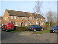
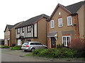
Great Portway
2000s houses in Great Denham.
Image: © Burgess Von Thunen
Taken: 18 Feb 2013
0.06 miles
3
Whitings
2000s houses in Great Denham.
Image: © Burgess Von Thunen
Taken: 8 Jan 2013
0.10 miles
4
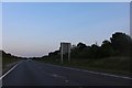
The Branston Way, Kempston
The A6 has mysteriously become the A428.
Image: © David Howard
Taken: 29 Jun 2019
0.11 miles
5
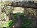
Mind Yer 'Ead
A fallen tree on the Ouse Valley Way.
Image: © Burgess Von Thunen
Taken: 28 Mar 2012
0.15 miles
6
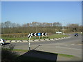
The Frank Branston Way
Roundabout on a new part of the A428.
Image: © Burgess Von Thunen
Taken: 28 Mar 2012
0.16 miles
7
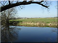
River Great Ouse
Near Great Denham.
Image: © Burgess Von Thunen
Taken: 28 Mar 2012
0.17 miles
8
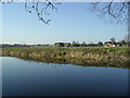
River Great Ouse
Looking towards Box End Park, a water ski, wakeboarding and conference venue.
Image: © Burgess Von Thunen
Taken: 28 Mar 2012
0.18 miles