IMAGES TAKEN NEAR TO
Coventry Road, BEDFORD, MK40 4EL
Introduction
This page details the photographs taken nearby to Coventry Road, MK40 4EL by members of the Geograph project.
The Geograph project started in 2005 with the aim of publishing, organising and preserving representative images for every square kilometre of Great Britain, Ireland and the Isle of Man.

There are currently over 7.5m images from over14,400 individuals and you can help contribute to the project by visiting https://www.geograph.org.uk
Image Map
Images are licensed for reuse under creativecommons.org/licenses/by-sa/2.0
Notes
- Clicking on the map will re-center to the selected point.
- The higher the marker number, the further away the image location is from the centre of the postcode.
Image Listing (13 Images Found)
Images are licensed for reuse under creativecommons.org/licenses/by-sa/2.0
Image
Details
Distance

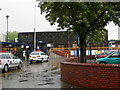
7
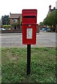
Elizabeth II postbox on Bromham Road
Postbox No. MK40 73.
Image: © JThomas
Taken: 21 Sep 2022
0.22 miles
10
Bedford Midland Road Station
This is the mainline station, trains between London and Sheffield often stop here, and it is also the starting point for some Capital Connect services.
Image: © Danny P Robinson
Taken: 17 May 2007
0.24 miles