IMAGES TAKEN NEAR TO
Cutcliffe Grove, BEDFORD, MK40 4DD
Introduction
This page details the photographs taken nearby to Cutcliffe Grove, MK40 4DD by members of the Geograph project.
The Geograph project started in 2005 with the aim of publishing, organising and preserving representative images for every square kilometre of Great Britain, Ireland and the Isle of Man.

There are currently over 7.5m images from over14,400 individuals and you can help contribute to the project by visiting https://www.geograph.org.uk
Image Map
Images are licensed for reuse under creativecommons.org/licenses/by-sa/2.0
Notes
- Clicking on the map will re-center to the selected point.
- The higher the marker number, the further away the image location is from the centre of the postcode.
Image Listing (22 Images Found)
Images are licensed for reuse under creativecommons.org/licenses/by-sa/2.0
Image
Details
Distance
2
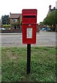
Elizabeth II postbox on Bromham Road
Postbox No. MK40 73.
Image: © JThomas
Taken: 21 Sep 2022
0.06 miles

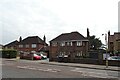
8
Bedford
Bromham Road crossing the Midland main line just North of Bedford Railway Station.
Image: © Peter McDermott
Taken: 12 Sep 2014
0.15 miles
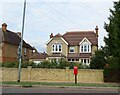
9
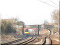
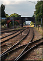
Bromham Road bridge, Bedford
This bridge, viewed from the north end of the railway station, carries Bromham Road (A428) over the Midland main railway line. A 'Meridian' train is seen heading north out of the station.
Image: © Stephen Craven
Taken: 6 Mar 2009
0.15 miles