IMAGES TAKEN NEAR TO
Bushmead Avenue, BEDFORD, MK40 3QW
Introduction
This page details the photographs taken nearby to Bushmead Avenue, MK40 3QW by members of the Geograph project.
The Geograph project started in 2005 with the aim of publishing, organising and preserving representative images for every square kilometre of Great Britain, Ireland and the Isle of Man.

There are currently over 7.5m images from over14,400 individuals and you can help contribute to the project by visiting https://www.geograph.org.uk
Image Map
Images are licensed for reuse under creativecommons.org/licenses/by-sa/2.0
Notes
- Clicking on the map will re-center to the selected point.
- The higher the marker number, the further away the image location is from the centre of the postcode.
Image Listing (122 Images Found)
Images are licensed for reuse under creativecommons.org/licenses/by-sa/2.0
Image
Details
Distance
1
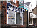
Community policing?
It really is a police facility, not a joke - the limited opening hours are on the door, and the window display consists of various useful notices.
Image: © M J Richardson
Taken: 6 Sep 2007
0.08 miles
2
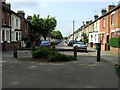
Bower Street
The Russell Park end of the street.
Image: © Thomas Nugent
Taken: 17 May 2010
0.08 miles
3
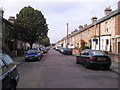
Bower Street
The southern end of Bower Street, a long terrace of Victorian houses, mostly 1880s, bordering on Russell Park.
Image: © M J Richardson
Taken: 9 Sep 2007
0.09 miles
4
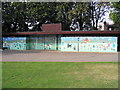
Russell Park Mural
A mural featuring the various recreational activities that are popular in the park, on the walls of the changing rooms.
Image: © M J Richardson
Taken: 9 Sep 2007
0.10 miles
5
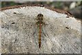
Dragonfly on a tree stump
A Common Darter (Sympetrum striolatum).
Image: © M J Richardson
Taken: 13 Aug 2009
0.11 miles
6
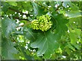
Knopper gall on oak
A gall caused by a cynipid wasp [Andricus quercuscalicis]. Usually one or two galls can be seen at the side of the acorn, but these are completely obscuring the acorn. A relatively recent introduction to Britain, but now quite widespread. See Lairich Rig's image and detailed account Image
Image: © M J Richardson
Taken: 13 Aug 2009
0.11 miles
7
Eat Fish
A seafood restaurant on The Embankment at Russell Park. The restaurant was known as the Russell Park Cafe in the 1950s & 60s.
Image: © Thomas Nugent
Taken: 17 May 2010
0.13 miles
8
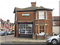
Signs of earlier times
This building on the corner of Pembroke Street and Castle Road was once Goodband's, the baker's.
Image: © M J Richardson
Taken: 29 Nov 2011
0.13 miles

10
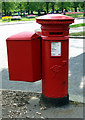
VR pillar box
On Rothsay Road at The Embankment. Spoiled by the addition of the big square box.
Image: © Thomas Nugent
Taken: 17 May 2010
0.14 miles