IMAGES TAKEN NEAR TO
Howbury Street, BEDFORD, MK40 3QT
Introduction
This page details the photographs taken nearby to Howbury Street, MK40 3QT by members of the Geograph project.
The Geograph project started in 2005 with the aim of publishing, organising and preserving representative images for every square kilometre of Great Britain, Ireland and the Isle of Man.

There are currently over 7.5m images from over14,400 individuals and you can help contribute to the project by visiting https://www.geograph.org.uk
Image Map
Images are licensed for reuse under creativecommons.org/licenses/by-sa/2.0
Notes
- Clicking on the map will re-center to the selected point.
- The higher the marker number, the further away the image location is from the centre of the postcode.
Image Listing (32 Images Found)
Images are licensed for reuse under creativecommons.org/licenses/by-sa/2.0
Image
Details
Distance
2
Community policing?
It really is a police facility, not a joke - the limited opening hours are on the door, and the window display consists of various useful notices.
Image: © M J Richardson
Taken: 6 Sep 2007
0.07 miles
3
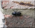
Lesser Stag Beetle adult
An adult female [Dorcus parallelipipedus] in a Bedford garden very near a fallen and rotting pear tree trunk that has been left to encourage wildlife. The larvae Image feed on rotten wood for 3-4 years, and then pupate before emerging as an adult. They are quite large [22 x 9 mm], and southerly in distribution.
Image: © M J Richardson
Taken: 13 Jun 2011
0.08 miles
4
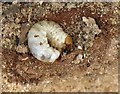
Lesser Stag Beetle larva
One of many in a rotting pear tree trunk that fell over in a garden and has been left to decay. The larvae feed for 3-4 years before pupating and then emerging as an adult beetle. The species [Dorcus parallelipipedus] has a southern distribution and can be quite common in suitable habitats. For the adult see Image
Image: © M J Richardson
Taken: 15 Jun 2011
0.08 miles
5
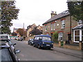
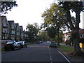
Bower Street, Bedford
The northern end of a long row of Victorian terraces, with a more modern building and new housing development at the junction with Goldington Road.
Image: © M J Richardson
Taken: 6 Sep 2007
0.10 miles
6
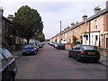
Bower Street
The southern end of Bower Street, a long terrace of Victorian houses, mostly 1880s, bordering on Russell Park.
Image: © M J Richardson
Taken: 9 Sep 2007
0.10 miles
7
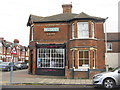
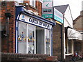
Signs of earlier times
This building on the corner of Pembroke Street and Castle Road was once Goodband's, the baker's.
Image: © M J Richardson
Taken: 29 Nov 2011
0.12 miles
8
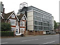
Goldington Road, Bedford
The renaissance of a 60s office building, converted into apartments, and one of the original houses of the area.
Image: © M J Richardson
Taken: 21 Sep 2017
0.13 miles
9
Castle Lower School, Goldington Road, Bedford
When I attended this school in the late 1950's and early 60's, it was called Goldington Road Junior School. The Infants school was in the building behind this one.
I remember the headmaster was Mr Mackenzie, and my teacher in my last year was Miss Webb, who managed a class of about 50 children. The years below mine had smaller classes - Brickhill junior and infants schools opened and children were moved to the new school. One of the teachers moved as well, Mr Gunning.
Image: © Rich Tea
Taken: 19 Jun 2009
0.13 miles
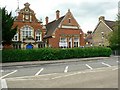
10
Castle Lower School, Bedford
The school, on Goldington Road, was built in 1899.
Previously known as Goldington Road Junior School (in the late 1950's & early 1960's)
Image: © M J Richardson
Taken: 7 Sep 2007
0.13 miles