IMAGES TAKEN NEAR TO
Goldington Road, BEDFORD, MK40 3EN
Introduction
This page details the photographs taken nearby to Goldington Road, MK40 3EN by members of the Geograph project.
The Geograph project started in 2005 with the aim of publishing, organising and preserving representative images for every square kilometre of Great Britain, Ireland and the Isle of Man.

There are currently over 7.5m images from over14,400 individuals and you can help contribute to the project by visiting https://www.geograph.org.uk
Image Map
Images are licensed for reuse under creativecommons.org/licenses/by-sa/2.0
Notes
- Clicking on the map will re-center to the selected point.
- The higher the marker number, the further away the image location is from the centre of the postcode.
Image Listing (15 Images Found)
Images are licensed for reuse under creativecommons.org/licenses/by-sa/2.0
Image
Details
Distance
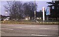
1
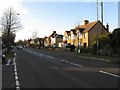
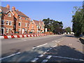
Goldington Road
The main road into Bedford from the east [A428].
Image: © M J Richardson
Taken: 4 Dec 2008
0.07 miles
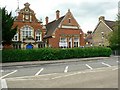
4
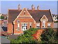
Castle Lower School, Bedford
The kitchen building, presumably the same age as the school - 1899. In the late 1950s this building was Goldington Road Infants School, which pupils attended from the age of 4 or 5 until they were 8 when they moved into the Junior School building adjacent to Goldington Road Image, now Castle Lower School.
Image: © M J Richardson
Taken: 7 Sep 2007
0.20 miles
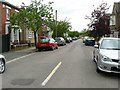
5
Goldington Road, Bedford
New building development on the site of Marshall's Garage and car dealers, which dated from the late 1950s, on the A428, the main route from Bedford town centre towards the A1 and Cambridge.
Image: © M J Richardson
Taken: 7 Sep 2007
0.20 miles
7
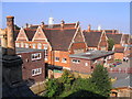
Castle Lower School, Bedford
The school, on Goldington Road, was built in 1899.
Previously known as Goldington Road Junior School (in the late 1950's & early 1960's)
Image: © M J Richardson
Taken: 7 Sep 2007
0.20 miles
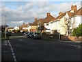
8
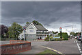
The White Horse pub, Bedford
Located in Newnham Avenue at the junction with Rosamond Road.
In the late 1960s/early 1970s, this pub was popular with students from the nearby Bedford College of Education (now University of Bedfordshire), as the college had no bar of its own at the time.
Image: © Richard Dorrell
Taken: 5 Oct 2019
0.21 miles
9
Castle Lower School, Goldington Road, Bedford
When I attended this school in the late 1950's and early 60's, it was called Goldington Road Junior School. The Infants school was in the building behind this one.
I remember the headmaster was Mr Mackenzie, and my teacher in my last year was Miss Webb, who managed a class of about 50 children. The years below mine had smaller classes - Brickhill junior and infants schools opened and children were moved to the new school. One of the teachers moved as well, Mr Gunning.
Image: © Rich Tea
Taken: 19 Jun 2009
0.23 miles
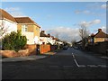
10
Goldington Road at the junction of Polhill Avenue
The University of Bedfordshire is on the right
Image: © David Howard
Taken: 30 Jan 2022
0.24 miles