IMAGES TAKEN NEAR TO
Chesterton Mews, BEDFORD, MK40 2TB
Introduction
This page details the photographs taken nearby to Chesterton Mews, MK40 2TB by members of the Geograph project.
The Geograph project started in 2005 with the aim of publishing, organising and preserving representative images for every square kilometre of Great Britain, Ireland and the Isle of Man.

There are currently over 7.5m images from over14,400 individuals and you can help contribute to the project by visiting https://www.geograph.org.uk
Image Map
Images are licensed for reuse under creativecommons.org/licenses/by-sa/2.0
Notes
- Clicking on the map will re-center to the selected point.
- The higher the marker number, the further away the image location is from the centre of the postcode.
Image Listing (18 Images Found)
Images are licensed for reuse under creativecommons.org/licenses/by-sa/2.0
Image
Details
Distance
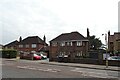
1
Cul-de-Sac
A short cul-de-sac leading to sports fields in Bedford.
Image: © Richard Schmidt
Taken: 9 Jun 2007
0.11 miles
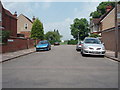
2
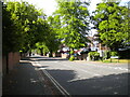
Milton Road, Bedford
Seen from its junction with Spenser Road.
Image: © Richard Vince
Taken: 7 May 2022
0.12 miles
3
Chaucer Road, Bedford
At its junction with Milton Road.
Image: © Richard Vince
Taken: 7 May 2022
0.14 miles
4
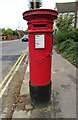
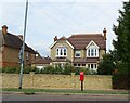
Victorian Postbox on Shakespeare Road
Postbox No. MK40 26.
Image: © JThomas
Taken: 23 Sep 2022
0.17 miles
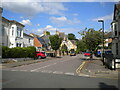
5
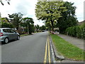
Shakespeare Road, Bedford
At its junction with Tudor Close (right).
Image: © Richard Vince
Taken: 7 May 2022
0.18 miles
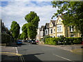
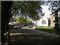
6
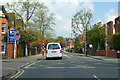
A5141 Shakespeare Road, Bedford
Looking north at the Cowper Road/Warwick Avenue crossroads.
Image: © Robin Webster
Taken: 2 May 2021
0.19 miles
9
South end of Spenser Road, Bedford
Seen from its junction with Chaucer Road.
Image: © Richard Vince
Taken: 7 May 2022
0.22 miles