IMAGES TAKEN NEAR TO
Tavistock Place, BEDFORD, MK40 2RY
Introduction
This page details the photographs taken nearby to Tavistock Place, MK40 2RY by members of the Geograph project.
The Geograph project started in 2005 with the aim of publishing, organising and preserving representative images for every square kilometre of Great Britain, Ireland and the Isle of Man.

There are currently over 7.5m images from over14,400 individuals and you can help contribute to the project by visiting https://www.geograph.org.uk
Image Map
Images are licensed for reuse under creativecommons.org/licenses/by-sa/2.0
Notes
- Clicking on the map will re-center to the selected point.
- The higher the marker number, the further away the image location is from the centre of the postcode.
Image Listing (98 Images Found)
Images are licensed for reuse under creativecommons.org/licenses/by-sa/2.0
Image
Details
Distance
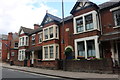
1
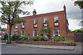
House in The Crescent, Bedford
This house was the home of Amy Walmsley, who was principal of the Froebel Kindergarten School and Training College, which later became Bedford Training College for Teachers, and subsequently Bedford College of Education. The house adjoins the Bedford Training College building (on the right), which continued to be part of Bedford College of Education until 1982.
Bedford Training College building: Image
Image: © Richard Dorrell
Taken: 5 Oct 2019
0.04 miles
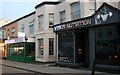
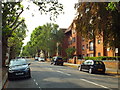
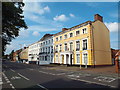
2
Terraced houses on Union Street, Bedford
Image: © David Howard
Taken: 11 Jul 2020
0.05 miles
3
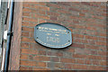
Plaque on former Bedford Training College
Detail of a plaque on a building at the junction of The Crescent and Tavistock Street.
Wider view of the building: Image
Image: © Richard Dorrell
Taken: 5 Oct 2019
0.05 miles
4

Former Bedford Training College
The entrance to the building is behind the trees, in The Crescent, but here the building is photographed from Tavistock Street. The building bears a blue plaque stating that it was Bedford Training College from 1882. In the late 1960's, I was a student at Bedford College of Education (main site in Polhill Avenue) and I attended lectures in this building.
Blue plaque detail: Image
Image: © Richard Dorrell
Taken: 5 Oct 2019
0.05 miles
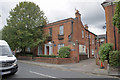
5
Number 6, The Crescent
In the late 1960s/early 70s, this house belonged to Bedford College of Education, and as a student of that college, I attended tutorials in one of the ground floor rooms, which was a 'through room' with window to the front and french windows to the rear garden.
The house now bears a blue plaque which provides the information that Admiral H. Smyth FRS, Astronomer and President of the Royal Astronomical Society built his observatory here in 1827.
Image: © Richard Dorrell
Taken: 5 Oct 2019
0.05 miles
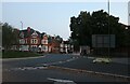
7
Warwick Avenue, Bedford
Warwick Avenue is a residential road in Bedford.
Image: © Malc McDonald
Taken: 21 Jul 2018
0.07 miles
8
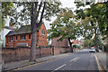
The Crescent, Bedford
A slightly odd name, as the road is almost straight. Viewed here from Dame Alice Street.
Several of the buildings in The Crescent bear blue plaques. The plaque on the nearest building on the left reads: Fanny Elizabeth Eagles (1836 - 1907) 'Sister Fanny', Church of England Deaconess. Community worker and founder of St Ethelreda's Children's Home here (1881 - 1984).
Image: © Richard Dorrell
Taken: 5 Oct 2019
0.09 miles
9
Housing terrace on Union Street, Bedford
A terrace of town houses on Union Street in Bedford.
Union Street forms part of the A6 trunk road.
Image: © Malc McDonald
Taken: 21 Jul 2018
0.09 miles