IMAGES TAKEN NEAR TO
St. Michaels Road, BEDFORD, MK40 2LZ
Introduction
This page details the photographs taken nearby to St. Michaels Road, MK40 2LZ by members of the Geograph project.
The Geograph project started in 2005 with the aim of publishing, organising and preserving representative images for every square kilometre of Great Britain, Ireland and the Isle of Man.

There are currently over 7.5m images from over14,400 individuals and you can help contribute to the project by visiting https://www.geograph.org.uk
Image Map
Images are licensed for reuse under creativecommons.org/licenses/by-sa/2.0
Notes
- Clicking on the map will re-center to the selected point.
- The higher the marker number, the further away the image location is from the centre of the postcode.
Image Listing (33 Images Found)
Images are licensed for reuse under creativecommons.org/licenses/by-sa/2.0
Image
Details
Distance
1
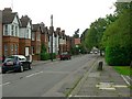
St Alban Road, Bedford
Looking from the junction with Kimbolton Road, St Andrew's Church is out of the picture to the right.
And note that it's St Alban Road, not St Alban's Road !
Image: © Rich Tea
Taken: 19 Jun 2009
0.10 miles
2
Kimbolton Road, Bedford
And the junction with St Alban Road
Image: © Rich Tea
Taken: 19 Jun 2009
0.10 miles
3
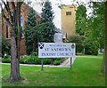
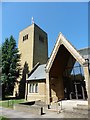
St Andrew's Church, Kimbolton Road, Bedford
The church I attended as a child.
The church was originally set up in a corrugated iron shed behind the present building which I think was erected in the 1920's. The shed then became a church hall. The tower and extensions were built in the 1960's and 70's and the present Parish Centre was built within the past 15 years, replacing an earlier building north of the church.
Image: © Rich Tea
Taken: 19 Jun 2009
0.11 miles
4
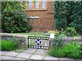
Garden of Remembrance, St Andrew's Church, Bedford
By the south wall of the church. The ashes of parishioners are buried here.
Image: © Rich Tea
Taken: 19 Jun 2009
0.11 miles
5
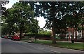
Park Avenue, Bedford
The bench wasn't there a year ago
Image: © David Howard
Taken: 11 Jul 2020
0.11 miles
8
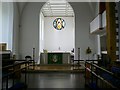
Interior of St Andrew's Church, Bedford
Traditionally churches are aligned east-west, but St Andrew's is aligned parallel with Kimbolton Road, so the altar is at the north-east end.
Image: © Rich Tea
Taken: 19 Jun 2009
0.12 miles
9
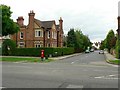
St Augustine's Road, Bedford
At its junction with Park Avenue.
The building on the left used to be Dial House Nursing Home (named after a sundial on the wall). I think it's a private house now - in the late 1990's the nursing home moved to larger premises in Dynevor Road, keeping the same name.
Image: © Rich Tea
Taken: 19 Jun 2009
0.12 miles
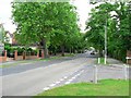
10
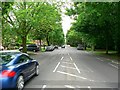
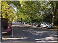
Park Avenue, Bedford
Looking south-west from the traffic island, by St Augustine's Road and the entrance to Bedford Park.
Image: © Rich Tea
Taken: 19 Jun 2009
0.12 miles