IMAGES TAKEN NEAR TO
Allhallows, BEDFORD, MK40 1LT
Introduction
This page details the photographs taken nearby to Allhallows, MK40 1LT by members of the Geograph project.
The Geograph project started in 2005 with the aim of publishing, organising and preserving representative images for every square kilometre of Great Britain, Ireland and the Isle of Man.

There are currently over 7.5m images from over14,400 individuals and you can help contribute to the project by visiting https://www.geograph.org.uk
Image Map
Images are licensed for reuse under creativecommons.org/licenses/by-sa/2.0
Notes
- Clicking on the map will re-center to the selected point.
- The higher the marker number, the further away the image location is from the centre of the postcode.
Image Listing (378 Images Found)
Images are licensed for reuse under creativecommons.org/licenses/by-sa/2.0
Image
Details
Distance
1
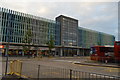
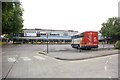
Bedford Bus Station
Full of United Counties buses in National Bus Company leaf green livery. Approaching the camera is 756, on route to Stewartby. It is a Bristol VR with ECW bodywork. This is an early version, later versions had a curved windscreen. Behind is a multi-storey car park. Spring must have been a bit late that year, the trees are only just starting to come into leaf.
Image: © Martin Addison
Taken: Unknown
0.01 miles
2
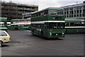
Bedford Bus Station
Stagecoach buses line up awaiting departure from the town's bus station.
Image: © Stephen McKay
Taken: 28 Apr 2010
0.01 miles

4
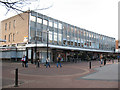
Bedford bus station: rear entrance
Several contributors have submitted photos of buses here, but this is the rear of the bus station building on Allhallows. There are retail units on the ground floor and mostly vacant-looking offices above.
Image: © Stephen Craven
Taken: 6 Mar 2009
0.01 miles
5
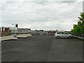
Top floor, Allhallows Car Park, Bedford
I was surprised to find the car park was not full on a Friday afternoon. The lowest 3 or 4 floors were quite full, the upper floors had some cars, but there were no cars on floors 9 & 10, apart from this one.
The building to the left is the BT building on St Loyes Street (originally known as Telephone House).
Image: © Rich Tea
Taken: 19 Jun 2009
0.01 miles
6
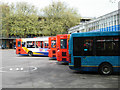
Bedford bus station, with the infamous X5 bus in the foreground
The X5 is a truly dire bus service between Oxford and Cambridge. It takes over 3 hours (often considerably over) and is prone to frequent breakdowns and sewage leakages. To be avoided at (almost) all costs!
Image: © Fractal Angel
Taken: 15 Jul 2007
0.02 miles
7
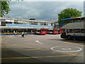
Bedford Bus Station
Built in the 1960's when it was mostly filled with green United Counties buses. It replaced a much smaller bus station on The Broadway opposite the end of Foster Hill Road.
Image: © Rich Tea
Taken: 19 Jun 2009
0.02 miles
8
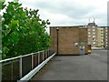
Plane trees by Allhallows Car Park, Bedford
In the 1960's, a row of saplings was planted along the pavement between Allhallows Car Park and the Bus Station. These are now tall plane trees, above floor 10.
A recent study looked at the oldest London Planes in London, and suggested that they have not yet reach maturity and could grow taller, even though they are more than 200 years old.
Image: © Rich Tea
Taken: 19 Jun 2009
0.02 miles
9
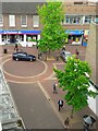
Greenhill St & Allhallows, Bedford
Looking down from the top floor of the Allhallows car park - Greenhill Street at the bottom, Allhallows crossing the picture.
Image: © Rich Tea
Taken: 19 Jun 2009
0.02 miles