IMAGES TAKEN NEAR TO
Portmarnock Close, MILTON KEYNES, MK3 7TH
Introduction
This page details the photographs taken nearby to Portmarnock Close, MK3 7TH by members of the Geograph project.
The Geograph project started in 2005 with the aim of publishing, organising and preserving representative images for every square kilometre of Great Britain, Ireland and the Isle of Man.

There are currently over 7.5m images from over14,400 individuals and you can help contribute to the project by visiting https://www.geograph.org.uk
Image Map
Images are licensed for reuse under creativecommons.org/licenses/by-sa/2.0
Notes
- Clicking on the map will re-center to the selected point.
- The higher the marker number, the further away the image location is from the centre of the postcode.
Image Listing (15 Images Found)
Images are licensed for reuse under creativecommons.org/licenses/by-sa/2.0
Image
Details
Distance
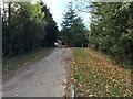
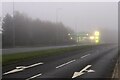
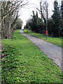
3
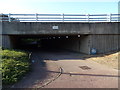
National Cycle Route 51, Milton Keynes
Underpass beneath the A421.
Image: © JThomas
Taken: 21 Sep 2019
0.09 miles
7
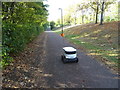
Starship Technologies delivery robot on National Cycle Route 51, Milton Keynes
These robots deliver parcels and groceries to addresses in Milton Keynes. Each robot is fitted with 10 cameras, ultrasound sensors, radar, and GPS and use sophisticated computer vision and software to identify objects in their path.
Image: © JThomas
Taken: 21 Sep 2019
0.14 miles
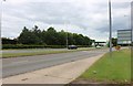
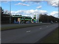
10
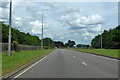
A421 Standing Way, Milton Keynes, heading north-east
Or H8 under the Milton Keynes road grid numbering system. The roundabout ahead is the intersection with V2.
Image: © Robin Webster
Taken: 9 Jun 2019
0.18 miles