IMAGES TAKEN NEAR TO
Humber Way, MILTON KEYNES, MK3 7PH
Introduction
This page details the photographs taken nearby to Humber Way, MK3 7PH by members of the Geograph project.
The Geograph project started in 2005 with the aim of publishing, organising and preserving representative images for every square kilometre of Great Britain, Ireland and the Isle of Man.

There are currently over 7.5m images from over14,400 individuals and you can help contribute to the project by visiting https://www.geograph.org.uk
Image Map (Loading...)


Getting Data...Please wait
Leaflet Map data © OpenStreetMap
Images are licensed for reuse under creativecommons.org/licenses/by-sa/2.0
Notes
- Clicking on the map will re-center to the selected point.
- The higher the marker number, the further away the image location is from the centre of the postcode.
Image Listing (6 Images Found)
Images are licensed for reuse under creativecommons.org/licenses/by-sa/2.0
Image
Details
Distance
1
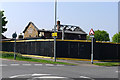
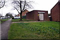
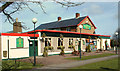
The White Hart, Bletchley
The remains after a fire destroyed the interior and the roof. Another pub closed, as the site will be redeveloped.
Image: © Cameraman
Taken: 19 Apr 2011
0.19 miles
2
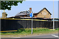
The White Hart, Bletchley
The remains after a fire destroyed the interior and the roof. Another pub closed, as the site will be redeveloped.
Image: © Cameraman
Taken: 19 Apr 2011
0.19 miles
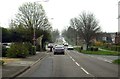
4
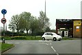
The junction of Shenley Road and Whaddon Way
Image: © Steve Daniels
Taken: 3 Apr 2014
0.22 miles