IMAGES TAKEN NEAR TO
Renfrew Way, MILTON KEYNES, MK3 7NY
Introduction
This page details the photographs taken nearby to Renfrew Way, MK3 7NY by members of the Geograph project.
The Geograph project started in 2005 with the aim of publishing, organising and preserving representative images for every square kilometre of Great Britain, Ireland and the Isle of Man.

There are currently over 7.5m images from over14,400 individuals and you can help contribute to the project by visiting https://www.geograph.org.uk
Image Map
Images are licensed for reuse under creativecommons.org/licenses/by-sa/2.0
Notes
- Clicking on the map will re-center to the selected point.
- The higher the marker number, the further away the image location is from the centre of the postcode.
Image Listing (13 Images Found)
Images are licensed for reuse under creativecommons.org/licenses/by-sa/2.0
Image
Details
Distance
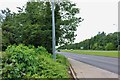
5
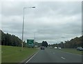
A421 approaching Elfield Park roundabout
Image: © John Firth
Taken: 22 Sep 2013
0.21 miles
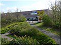
7
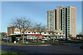
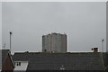
Melrose Shopping Centre, Bletchley
The shops at Melrose Avenue with Melluish Court, the only high-rise building in Bletchley, in the background.
Image: © Cameraman
Taken: 31 Dec 2001
0.21 miles
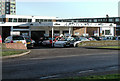
8
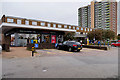
Tesco Express and Block of Flats, Melrose Avenue
Image: © David Dixon
Taken: 5 Sep 2016
0.22 miles
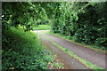
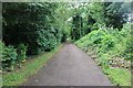
10
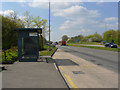
Standing Way Milton Keynes
Looking south-west from the roadside at Denbigh Hall.
Image: © Cameraman
Taken: 22 Apr 2010
0.22 miles