IMAGES TAKEN NEAR TO
Downing Close, MILTON KEYNES, MK3 6EP
Introduction
This page details the photographs taken nearby to Downing Close, MK3 6EP by members of the Geograph project.
The Geograph project started in 2005 with the aim of publishing, organising and preserving representative images for every square kilometre of Great Britain, Ireland and the Isle of Man.

There are currently over 7.5m images from over14,400 individuals and you can help contribute to the project by visiting https://www.geograph.org.uk
Image Map
Images are licensed for reuse under creativecommons.org/licenses/by-sa/2.0
Notes
- Clicking on the map will re-center to the selected point.
- The higher the marker number, the further away the image location is from the centre of the postcode.
Image Listing (474 Images Found)
Images are licensed for reuse under creativecommons.org/licenses/by-sa/2.0
Image
Details
Distance
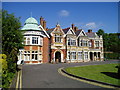
2
Within Bletchley Park, early September 2011 (xlix)
Image: © Basher Eyre
Taken: 7 Sep 2011
0.06 miles
3
MKARS HQ at Bletchley Park
See http://www.mkars.org.uk/
Image: © Basher Eyre
Taken: 7 Sep 2011
0.06 miles
4
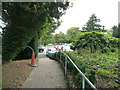
Wilton Avenue, Bletchley
Wilton Avenue leads to Bletchley Park, so the famous codebreakers would no doubt have walked this way many times during the Second World War; of course these houses would not have been here in those days. Although the local people were aware that some form of war work was taking place at the old mansion, the details never leaked out - and the townsfolk were far too discreet to enquire. In fact, the place remained shrouded in secrecy for many years after the war.
In this view, the entrance to the driving test centre is on the right.
Image: © Stephen McKay
Taken: 10 May 2023
0.07 miles
5
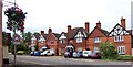
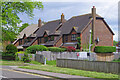
Row of Houses
A row of houses on Church Green Road opposite the eight belles public house. The middle building carries a plaque dated 1889. Clearly the buildings have been subjected to several alterations, and additions, over the years.
Image: © Len Williams
Taken: 7 Jul 2012
0.08 miles
6
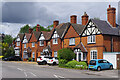
Church Green Road, Bletchley
This attractive terrace of similar but not uniform houses lines the southern end of Church Green Road from its junction with Buckingham Road.
Image: © Stephen McKay
Taken: 10 May 2023
0.08 miles
7
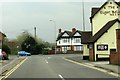
Church Green Road in Bletchley
Heading toward Buckingham Road.
Image: © Steve Daniels
Taken: 3 Apr 2014
0.08 miles
8
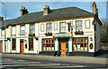
The George
In Buckingham Road, Bletchley.
It has since been converted to a restaurant.
Image: © Cameraman
Taken: Unknown
0.08 miles
9

Freeman Memorial Methodist Church, Bletchley
This church on Buckingham Road dates from 1895 when it replaced a chapel on Duck Lane (now called Newton Road). It was named after a Mr Freeman from London who 'was interested in the Methodist witness in Bletchley'; exactly who he was, why he had this particular interest and why the local Methodists obviously held him in high regard seems lost to history. The building was extended in 1967 to take account of the expansion of Bletchley's population.
Image: © Stephen McKay
Taken: 10 May 2023
0.09 miles
10
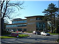
Andrew Peck Building, Bletchley Campus, Milton Keynes College
One of the many new buildings on the Bletchley campus of Milton Keynes College
Image: © Mr Biz
Taken: 23 Apr 2008
0.09 miles