IMAGES TAKEN NEAR TO
Corrigan Close, MILTON KEYNES, MK3 6BP
Introduction
This page details the photographs taken nearby to Corrigan Close, MK3 6BP by members of the Geograph project.
The Geograph project started in 2005 with the aim of publishing, organising and preserving representative images for every square kilometre of Great Britain, Ireland and the Isle of Man.

There are currently over 7.5m images from over14,400 individuals and you can help contribute to the project by visiting https://www.geograph.org.uk
Image Map
Images are licensed for reuse under creativecommons.org/licenses/by-sa/2.0
Notes
- Clicking on the map will re-center to the selected point.
- The higher the marker number, the further away the image location is from the centre of the postcode.
Image Listing (256 Images Found)
Images are licensed for reuse under creativecommons.org/licenses/by-sa/2.0
Image
Details
Distance
1
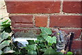
Benchmark on garage of #57 Church Green Road
Ordnance Survey cut mark benchmark described on the Bench Mark Database at http://www.bench-marks.org.uk/bm82656
Image: © Roger Templeman
Taken: 2 Mar 2017
0.05 miles
2
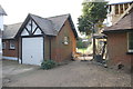
Garage and outbuilding at #57 Church Green Road
There is an OS benchmark Image on the near corner of the garage, behind the ivy
Image: © Roger Templeman
Taken: 2 Mar 2017
0.05 miles
3
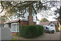
#57 Church Green Road, 'Holmbury'
There is an OS benchmark on the side of the attached garage Image
Image: © Roger Templeman
Taken: 2 Mar 2017
0.05 miles
5
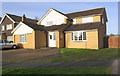
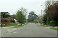
#44 Rickley Lane at Whalley Drive junction
Image: © Roger Templeman
Taken: 2 Mar 2017
0.08 miles
6
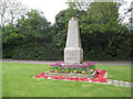
Bletchley: The War Memorial
This immaculately kept war memorial is on a grassy triangle on the north-east side of Rickley Lane.
Image: © Nigel Cox
Taken: 1 May 2010
0.10 miles
7
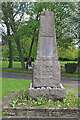
Old Bletchley War Memorial
This granite obelisk on Church Green Road commemorates those from the parish of Old Bletchley who were killed in the First World War, the Second World War and the conflict in Afghanistan. It was designed by John Chadwick, surveyor of the then Bletchley Urban District Council, whose son's name appears on the memorial, and was originally unveiled in 1920.
Image: © Stephen McKay
Taken: 10 May 2023
0.10 miles
8
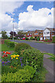
Rickley Lane, West Bletchley
Seen from the junction with South Lawne in the Bletchley suburbs.
Image: © Stephen McKay
Taken: 10 May 2023
0.11 miles
9
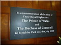
Within Bletchley Park, early September 2011 (lxxxvi)
Image: © Basher Eyre
Taken: 7 Sep 2011
0.13 miles
10
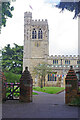
St Mary's Church, Bletchley
Parts of St Mary's church date from Norman times but the chancel is 13th century and there were additions in the 14th and 15th centuries. The church was restored in 1838 by William White; it is now grade I listed.
Image: © Stephen McKay
Taken: 10 May 2023
0.13 miles