IMAGES TAKEN NEAR TO
Warwick Road, MILTON KEYNES, MK3 6AF
Introduction
This page details the photographs taken nearby to Warwick Road, MK3 6AF by members of the Geograph project.
The Geograph project started in 2005 with the aim of publishing, organising and preserving representative images for every square kilometre of Great Britain, Ireland and the Isle of Man.

There are currently over 7.5m images from over14,400 individuals and you can help contribute to the project by visiting https://www.geograph.org.uk
Image Map
Images are licensed for reuse under creativecommons.org/licenses/by-sa/2.0
Notes
- Clicking on the map will re-center to the selected point.
- The higher the marker number, the further away the image location is from the centre of the postcode.
Image Listing (7 Images Found)
Images are licensed for reuse under creativecommons.org/licenses/by-sa/2.0
Image
Details
Distance
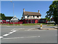
2
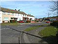
Avon Grove, Bletchley
From the junction with Tattenhoe Lane.
Image: © Cameraman
Taken: Unknown
0.11 miles
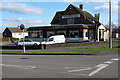
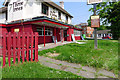
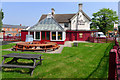
3
The Three Trees, Bletchley
Empty and waiting to be sold. But I think a buyer has been found.
Image: © Cameraman
Taken: 19 Apr 2011
0.24 miles
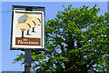
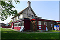
7
The Three Trees, Bletchley
Formerly know as the Shoulder of Mutton, this old farmhouse replaced the older Shoulder of Mutton public house that used to be opposite.
Image: © Cameraman
Taken: 22 Jun 2010
0.25 miles