IMAGES TAKEN NEAR TO
Honduras Gardens, MILTON KEYNES, MK3 5LY
Introduction
This page details the photographs taken nearby to Honduras Gardens, MK3 5LY by members of the Geograph project.
The Geograph project started in 2005 with the aim of publishing, organising and preserving representative images for every square kilometre of Great Britain, Ireland and the Isle of Man.

There are currently over 7.5m images from over14,400 individuals and you can help contribute to the project by visiting https://www.geograph.org.uk
Image Map
Images are licensed for reuse under creativecommons.org/licenses/by-sa/2.0
Notes
- Clicking on the map will re-center to the selected point.
- The higher the marker number, the further away the image location is from the centre of the postcode.
Image Listing (6 Images Found)
Images are licensed for reuse under creativecommons.org/licenses/by-sa/2.0
Image
Details
Distance
1
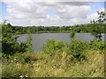
Jubilee Pit
One of the smaller pits from the old brickworks, this one is now used for fishing.
Image: © Mr Biz
Taken: 30 Jul 2006
0.12 miles
3
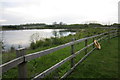
Willow Lake
An old pit from the brickworks now on the edge of a housing estate
Image: © Philip Jeffrey
Taken: 17 May 2012
0.20 miles
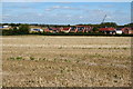
5
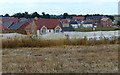
New housing at Newton Leys
Newton Leys is the southern most suburb of Milton Keynes.
Image: © Mat Fascione
Taken: 16 Aug 2015
0.24 miles