IMAGES TAKEN NEAR TO
Cottingham Grove, MILTON KEYNES, MK3 5AJ
Introduction
This page details the photographs taken nearby to Cottingham Grove, MK3 5AJ by members of the Geograph project.
The Geograph project started in 2005 with the aim of publishing, organising and preserving representative images for every square kilometre of Great Britain, Ireland and the Isle of Man.

There are currently over 7.5m images from over14,400 individuals and you can help contribute to the project by visiting https://www.geograph.org.uk
Image Map
Images are licensed for reuse under creativecommons.org/licenses/by-sa/2.0
Notes
- Clicking on the map will re-center to the selected point.
- The higher the marker number, the further away the image location is from the centre of the postcode.
Image Listing (17 Images Found)
Images are licensed for reuse under creativecommons.org/licenses/by-sa/2.0
Image
Details
Distance
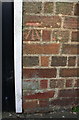
1
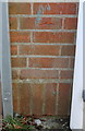
Benchmark on Holne Chase School
Ordnance Survey cut mark benchmark described on the Bench Mark Database at http://www.bench-marks.org.uk/bm82655
Image: © Roger Templeman
Taken: 2 Mar 2017
0.07 miles
2
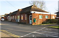
Holne Chase Primary School, Buckingham Road
There is an OS benchmark Image on the front of the building just beyond the far entrance
Image: © Roger Templeman
Taken: 2 Mar 2017
0.07 miles
3
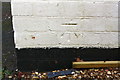
Benchmark on garage of #53 Buckingham Road
Ordnance Survey cut mark benchmark described on the Bench Mark Database at http://www.bench-marks.org.uk/bm82654
Image: © Roger Templeman
Taken: 2 Mar 2017
0.16 miles
4
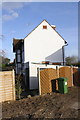
#53 Buckingham Road with garage
There is an OS benchmark Image on the near side of the garage near its front corner.
Image: © Roger Templeman
Taken: 2 Mar 2017
0.17 miles
7
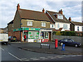
Old Bletchley Post Office
The shop is still there but the post office closed around 2006.
Image: © Cameraman
Taken: 16 Jan 2003
0.21 miles
8
#36 Church Green Road
There is an OS benchmark Image under the house number left of the door
Image: © Roger Templeman
Taken: 2 Mar 2017
0.23 miles
9
Benchmark on #36 Church Green Road
Ordnance Survey cut mark benchmark described on the Bench Mark Database at http://www.bench-marks.org.uk/bm82652
Image: © Roger Templeman
Taken: 2 Mar 2017
0.23 miles
10
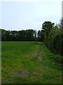
Public Footpath
The footpath that runs from the cemetery and allotment gardens to the Blue Lagoon.
Image: © Mr Biz
Taken: 3 May 2008
0.23 miles