IMAGES TAKEN NEAR TO
Windermere Drive, MILTON KEYNES, MK2 3NR
Introduction
This page details the photographs taken nearby to Windermere Drive, MK2 3NR by members of the Geograph project.
The Geograph project started in 2005 with the aim of publishing, organising and preserving representative images for every square kilometre of Great Britain, Ireland and the Isle of Man.

There are currently over 7.5m images from over14,400 individuals and you can help contribute to the project by visiting https://www.geograph.org.uk
Image Map
Images are licensed for reuse under creativecommons.org/licenses/by-sa/2.0
Notes
- Clicking on the map will re-center to the selected point.
- The higher the marker number, the further away the image location is from the centre of the postcode.
Image Listing (5 Images Found)
Images are licensed for reuse under creativecommons.org/licenses/by-sa/2.0
Image
Details
Distance
1

Grand Union Canal: Reach in Fenny Stratford
This is the northern end of a virtually straight cut about 600 metres long, viewed looking southwards towards Stoke Hammond.
Image: © Nigel Cox
Taken: 14 Sep 2013
0.22 miles
2
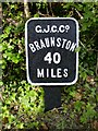
40 Miles to Braunston
One of many similar markers on the Grand Union Canal
Image: © Mike W Hallett
Taken: 13 Jun 2009
0.24 miles
3
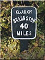
Replica milemarker by the Grand Union Canal, Bletchley
Replica milemarker by the Grand Union Canal, in parish of Bletchley (Milton Keynes District), North of the A4146 bridge.
Inscription reads:-
G.J.C.Co
BRAUNSTON
40
MILES
Surveyed
Milestone Society National ID: GUC-40
Image: © Milestone Society
Taken: Unknown
0.24 miles
4
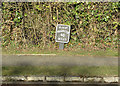
Milestone 40
Replica Grand Union milestone on towpath
Image: © Mike Todd
Taken: 6 Apr 2013
0.24 miles
5
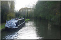
Grand Union Canal, Water Eaton
A narrowboat is moored just south of bridge 98A.
Image: © Stephen McKay
Taken: 13 Nov 2019
0.25 miles