IMAGES TAKEN NEAR TO
The Sidings, MILTON KEYNES, MK2 2XE
Introduction
This page details the photographs taken nearby to The Sidings, MK2 2XE by members of the Geograph project.
The Geograph project started in 2005 with the aim of publishing, organising and preserving representative images for every square kilometre of Great Britain, Ireland and the Isle of Man.

There are currently over 7.5m images from over14,400 individuals and you can help contribute to the project by visiting https://www.geograph.org.uk
Image Map
Images are licensed for reuse under creativecommons.org/licenses/by-sa/2.0
Notes
- Clicking on the map will re-center to the selected point.
- The higher the marker number, the further away the image location is from the centre of the postcode.
Image Listing (98 Images Found)
Images are licensed for reuse under creativecommons.org/licenses/by-sa/2.0
Image
Details
Distance
1
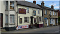
The Chequers, High Street North, Fenny Stratford
Image: © Cameraman
Taken: 23 Aug 2009
0.02 miles
4
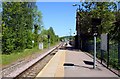
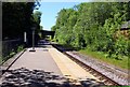
Fenny Stratford railway station
The railway line between Bletchley and Bedford was built in 1846 and later absorbed into the London and North Western Railway. The station building was constructed in that year in an attractive timber framed gothicised style, reputedly insisted upon by then Duke of Bedford for any new railway buildings in the vicinity of the Woburn estate. After a continuous rundown of the station infrastructure through the years, in 1968 it eventually became an unstaffed halt and the station building was sold into private ownership.
By virtue of its importance as a surviving early Victorian country railway station it was Grade II listed in 1975.
Image: © Nigel Cox
Taken: 1 May 2010
0.03 miles
5
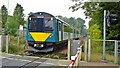
Fenny Stratford level crossing
A Class 230 Vivarail D-Train approaches Fenny Stratford Station on the Marston Vale line between Bedford and Bletchley.
Image: © Mark Percy
Taken: 9 Oct 2021
0.04 miles
6
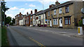
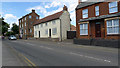
High Street North, Fenny Stratford
The view northwards from Aylesbury Street..
Image: © Cameraman
Taken: 23 Aug 2009
0.04 miles
8
The Chequers, High Street North, Fenny Stratford
Image: © Cameraman
Taken: 23 Aug 2009
0.04 miles
9
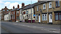
Grade House, High Street North, Fenny Stratford
The cream coloured house is known as Grade House and the three storey house beyond is the Red House.
Image: © Cameraman
Taken: 23 Aug 2009
0.04 miles
10
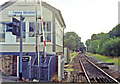
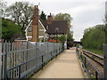
Fenny Stratford signalbox and station, 1991
View westward, towards Bletchley: ex-LNWR (Oxford) - Bletchley - Bedford - (Cambridge) line. This is the surviving section, between Bletchley and Bedford, of the formerly - and still potentially - important 'Varsity Line', which survived the 'Beeching Axe', the rest being closed 1/1/68. Although there were modern road barriers at this Simpson Road level-crossing, in 1991 they may still have been controlled from the signalbox, but the latter was since removed when the signalling was modernised. The single-platform 'station' seen ahead remains in use, albeit unstaffed, even though it is only a mile away from Bletchley station.
Image: © Ben Brooksbank
Taken: 18 Aug 1991
0.05 miles