IMAGES TAKEN NEAR TO
Earls Close, MILTON KEYNES, MK2 2UR
Introduction
This page details the photographs taken nearby to Earls Close, MK2 2UR by members of the Geograph project.
The Geograph project started in 2005 with the aim of publishing, organising and preserving representative images for every square kilometre of Great Britain, Ireland and the Isle of Man.

There are currently over 7.5m images from over14,400 individuals and you can help contribute to the project by visiting https://www.geograph.org.uk
Image Map
Images are licensed for reuse under creativecommons.org/licenses/by-sa/2.0
Notes
- Clicking on the map will re-center to the selected point.
- The higher the marker number, the further away the image location is from the centre of the postcode.
Image Listing (137 Images Found)
Images are licensed for reuse under creativecommons.org/licenses/by-sa/2.0
Image
Details
Distance
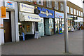
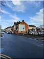
1
Princes Way, Bletchley
Looking west from the junction with North Street.
Image: © Cameraman
Taken: 20 Apr 2011
0.07 miles
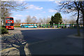
9
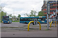
Bletchley Bus Station
When the creation of Milton Keynes new city was announced in 1967 the principal bus operator in the area, United Counties, must have thought it represented a huge opportunity for new traffic. As is well known, however, the planners of the day saw the motor car as the future and designed an urban environment around it; little thought was given to the provision of public transport. It wasn't until the 1980s that a new bus garage was built in the city at Winterhill (although it has since closed). In preparation for privatisation, a new operator called Milton Keynes Citybus took over in 1986; it ran a fleet of uncomfortable minibus conversions which appeared in a particularly insipid yellow and grey livery - these vehicles can have done little to encourage people to use the service. After various changes of ownership, the operation was eventually acquired by Arriva and is now run by their Shires and Essex division. At least they use proper buses and the main routes are reasonably frequent although, thanks to the way the city is laid out, there can be little penetration into the housing estates. Bletchley bus station forms the southern hub and a bus on route 5 to Wolverton via Central Milton Keynes can be seen departing.
Image: © Stephen McKay
Taken: 10 May 2023
0.13 miles