IMAGES TAKEN NEAR TO
Victoria Road, MILTON KEYNES, MK2 2NN
Introduction
This page details the photographs taken nearby to Victoria Road, MK2 2NN by members of the Geograph project.
The Geograph project started in 2005 with the aim of publishing, organising and preserving representative images for every square kilometre of Great Britain, Ireland and the Isle of Man.

There are currently over 7.5m images from over14,400 individuals and you can help contribute to the project by visiting https://www.geograph.org.uk
Image Map
Images are licensed for reuse under creativecommons.org/licenses/by-sa/2.0
Notes
- Clicking on the map will re-center to the selected point.
- The higher the marker number, the further away the image location is from the centre of the postcode.
Image Listing (70 Images Found)
Images are licensed for reuse under creativecommons.org/licenses/by-sa/2.0
Image
Details
Distance
1
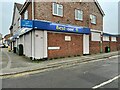
Off licence in Denmark Street
Hosting the plaque to Akroyd Stuart Image
Image: © Philip Jeffrey
Taken: 23 Jan 2022
0.03 miles
2
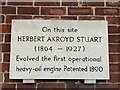
Plaque to the inventor of the heavy oil engine
Herbert Akroyd Stuart that is, not Rudolf Diesel who invented a heavy oil engine a few years later.
Image: © Philip Jeffrey
Taken: 23 Jan 2022
0.03 miles
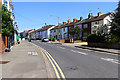
4
The Willows, Victoria Road, Bletchley
This house is now home to Heritage and Sons, Undertakers.
Image: © Cameraman
Taken: 27 Apr 2011
0.05 miles
5
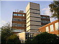
BT Telephone Exchange
Milton Keynes main telephone exchange, and a driver depot.
Image: © Mr Biz
Taken: 24 Jul 2006
0.07 miles
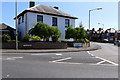
6
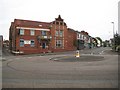
Fenny Stratford: Former Urban District Council offices
The Fenny Stratford Urban District Council was founded in 1895 and the foundation stone for their offices, at the junction of Queensway (to the left), Victoria Road (ahead), and Vicarage Road (to the right), was laid in 1903. In 1911 the body became Bletchley Urban District Council before that too disappeared in 1974 following the major reorganization of local government as a result of the Local Government Act of 1972. In 1974 the council became part of the District Authority and Borough of Milton Keynes.
A later use of the building has been as a Masonic centre, but the building currently appears to be available for renting.
Image: © Nigel Cox
Taken: 1 May 2010
0.08 miles
7

Telephone Exchange, Fenny Stratford (2)
Taken from Church Street, this TE rather resembles an office block, and is one of six TEs serving Milton Keynes City. The original TE would appear to be to the left of the photo, whilst the taller extension on the right was added more recently. To the right of the photo can be seen the black gate, which has two white BT warning notices on it, whilst the red notice adjacent to them says "This gate must be kept shut at all times". A BT Openreach vehicle can just be seen behind the gate.
Image: © David Hillas
Taken: 20 Sep 2014
0.10 miles
8

Telephone Exchange, Fenny Stratford (1)
Taken from Tavistock Street, this TE is located at 90 Victoria Road, MK2 2PA and used to take the name Milton Keynes. Besides Fenny Stratford, this TE also serves Bletchley, Bow Brickhill, Newton Longville and Water Eaton nearby. Mobile phone aerials can be seen on the roof of this building.
Image: © David Hillas
Taken: 20 Sep 2014
0.11 miles
9
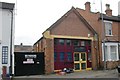
Bletchley old fire station
Bletchley old fire station, 38A Church Street, Bletchley, Buckinghamshire, which was replaced by Image
Image: © Kevin Hale
Taken: 24 Nov 2007
0.11 miles
10
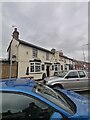
The Maltsters free house
The Maltsters free house on Aylesbury Street, Fenny Stratford
Image: © Ryan Griffiths
Taken: 24 Jul 2021
0.12 miles