IMAGES TAKEN NEAR TO
Chestnut Crescent, MILTON KEYNES, MK2 2JZ
Introduction
This page details the photographs taken nearby to Chestnut Crescent, MK2 2JZ by members of the Geograph project.
The Geograph project started in 2005 with the aim of publishing, organising and preserving representative images for every square kilometre of Great Britain, Ireland and the Isle of Man.

There are currently over 7.5m images from over14,400 individuals and you can help contribute to the project by visiting https://www.geograph.org.uk
Image Map
Images are licensed for reuse under creativecommons.org/licenses/by-sa/2.0
Notes
- Clicking on the map will re-center to the selected point.
- The higher the marker number, the further away the image location is from the centre of the postcode.
Image Listing (9 Images Found)
Images are licensed for reuse under creativecommons.org/licenses/by-sa/2.0
Image
Details
Distance
5
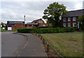
The former Plough public house on Manor Road
It was converted into a mosque in 2011.
Image: © Mat Fascione
Taken: 8 Aug 2015
0.16 miles
6
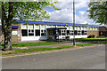
Bletchley Library, Westfield Road, Bletchley
Image: © Cameraman
Taken: 12 Apr 2011
0.24 miles
7
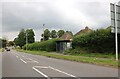
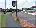
Water Eaton Church Centre, Drayton Road
The house extreme right is Sycamore House.
Image: © Cameraman
Taken: 9 May 2010
0.24 miles
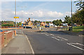
8
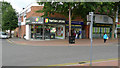
Herbies pizza, Queensway, Bletchley
Situated in Queensway on the corner of Westfield Road.
Image: © Cameraman
Taken: 20 Jul 2009
0.25 miles
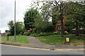
9
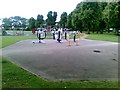
Play area off Queensway, Milton Keynes
Image: © Alex McGregor
Taken: 13 Jun 2011
0.25 miles