IMAGES TAKEN NEAR TO
Thrupp Close, MILTON KEYNES, MK19 7PL
Introduction
This page details the photographs taken nearby to Thrupp Close, MK19 7PL by members of the Geograph project.
The Geograph project started in 2005 with the aim of publishing, organising and preserving representative images for every square kilometre of Great Britain, Ireland and the Isle of Man.

There are currently over 7.5m images from over14,400 individuals and you can help contribute to the project by visiting https://www.geograph.org.uk
Image Map
Images are licensed for reuse under creativecommons.org/licenses/by-sa/2.0
Notes
- Clicking on the map will re-center to the selected point.
- The higher the marker number, the further away the image location is from the centre of the postcode.
Image Listing (34 Images Found)
Images are licensed for reuse under creativecommons.org/licenses/by-sa/2.0
Image
Details
Distance
2
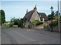
Castlethorpe Cottage
A thatched house in Castlethorpe, which according to the date over the door is exactly 200 years older than I am!
Image: © Richard Schmidt
Taken: 20 May 2007
0.09 miles
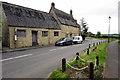
3
Castlethorpe Road Junction
House at the junction of Bullington End Road and North Street.
Image: © Ian Rob
Taken: 29 Nov 2019
0.09 miles
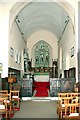
5
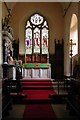
St Simon & St Jude, Castlethorpe, Bucks - Chancel
Image: © John Salmon
Taken: 10 Sep 2001
0.10 miles
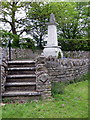
6
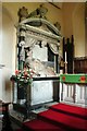
St Simon & St Jude, Castlethorpe, Bucks - Monument
Monument of Sir Thomas Tyrrell
Image: © John Salmon
Taken: 10 Sep 2001
0.10 miles
8
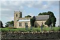
St Simon & St Jude, Castlethorpe, Bucks
Image: © John Salmon
Taken: 10 Sep 2001
0.10 miles
9
St Simon & St Jude, Castlethorpe, Bucks - East end
Image: © John Salmon
Taken: 10 Sep 2001
0.11 miles