IMAGES TAKEN NEAR TO
Weavers End, MILTON KEYNES, MK19 7PA
Introduction
This page details the photographs taken nearby to Weavers End, MK19 7PA by members of the Geograph project.
The Geograph project started in 2005 with the aim of publishing, organising and preserving representative images for every square kilometre of Great Britain, Ireland and the Isle of Man.

There are currently over 7.5m images from over14,400 individuals and you can help contribute to the project by visiting https://www.geograph.org.uk
Image Map
Images are licensed for reuse under creativecommons.org/licenses/by-sa/2.0
Notes
- Clicking on the map will re-center to the selected point.
- The higher the marker number, the further away the image location is from the centre of the postcode.
Image Listing (20 Images Found)
Images are licensed for reuse under creativecommons.org/licenses/by-sa/2.0
Image
Details
Distance
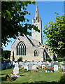
1
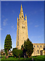
Hanslope Church
Here in Hanslope you will find Buckinghamshire's tallest spire that stands out across the area north of Milton Keynes.
Image: © David Neale
Taken: 29 Nov 2004
0.06 miles
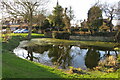
3
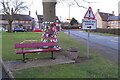
Hanslope tree of hope on the village green
Image: © Philip Jeffrey
Taken: 6 Feb 2021
0.09 miles
4
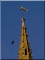
Weathervane on Hanslope Church
A dog with an arrow in its paw.
Image: © tristan forward
Taken: Unknown
0.13 miles

6
The Church of St James the Great in Hanslope
Image: © Mat Fascione
Taken: 8 Aug 2015
0.13 miles
7
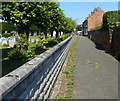
Path next to the Church of St James the Great
Image: © Mat Fascione
Taken: 8 Aug 2015
0.13 miles

10
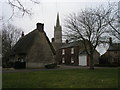
St James church spire Hanslope
From Park Road looking across The Green to St James church spire Hanslope
Image: © Shaun Ferguson
Taken: 17 Feb 2011
0.13 miles