IMAGES TAKEN NEAR TO
Newport Road, MILTON KEYNES, MK19 7ND
Introduction
This page details the photographs taken nearby to Newport Road, MK19 7ND by members of the Geograph project.
The Geograph project started in 2005 with the aim of publishing, organising and preserving representative images for every square kilometre of Great Britain, Ireland and the Isle of Man.

There are currently over 7.5m images from over14,400 individuals and you can help contribute to the project by visiting https://www.geograph.org.uk
Image Map
Images are licensed for reuse under creativecommons.org/licenses/by-sa/2.0
Notes
- Clicking on the map will re-center to the selected point.
- The higher the marker number, the further away the image location is from the centre of the postcode.
Image Listing (7 Images Found)
Images are licensed for reuse under creativecommons.org/licenses/by-sa/2.0
Image
Details
Distance

4
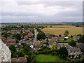
North East from Hanslope church
Hanslope church has a very tall and recognisable spire. This is the view from the top of the church tower, looking north east towards the M1.
Image: © D J Cook
Taken: 25 Jul 2004
0.15 miles
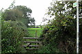
5
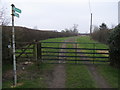
Footpath and bridleway by The Shieling
Footpath and bridleway towards the M1 by The Shieling
Image: © Shaun Ferguson
Taken: 17 Feb 2011
0.19 miles