IMAGES TAKEN NEAR TO
Stratford Road, MILTON KEYNES, MK19 7JA
Introduction
This page details the photographs taken nearby to Stratford Road, MK19 7JA by members of the Geograph project.
The Geograph project started in 2005 with the aim of publishing, organising and preserving representative images for every square kilometre of Great Britain, Ireland and the Isle of Man.

There are currently over 7.5m images from over14,400 individuals and you can help contribute to the project by visiting https://www.geograph.org.uk
Image Map
Images are licensed for reuse under creativecommons.org/licenses/by-sa/2.0
Notes
- Clicking on the map will re-center to the selected point.
- The higher the marker number, the further away the image location is from the centre of the postcode.
Image Listing (49 Images Found)
Images are licensed for reuse under creativecommons.org/licenses/by-sa/2.0
Image
Details
Distance
1
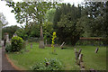
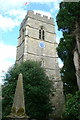
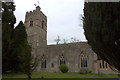
St Peter and St Paul churchyard, Cosgrove
Image: © Robert Eva
Taken: 8 May 2017
0.04 miles
4
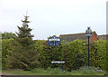
Yardley Road, Cosgrove
A village sign and a school sign.
Image: © Robert Eva
Taken: 8 May 2017
0.09 miles
10
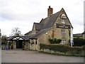
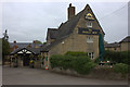
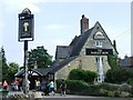
The Barley Mow Pub, Cosgrove
The Stocks, Cosgrove, Milton Keynes MK19 7JD on the Grand Union Canal
Image: © canalandriversidepubs co uk
Taken: 5 Feb 2010
0.14 miles