IMAGES TAKEN NEAR TO
Burrow Ash Close, MILTON KEYNES, MK19 7HU
Introduction
This page details the photographs taken nearby to Burrow Ash Close, MK19 7HU by members of the Geograph project.
The Geograph project started in 2005 with the aim of publishing, organising and preserving representative images for every square kilometre of Great Britain, Ireland and the Isle of Man.

There are currently over 7.5m images from over14,400 individuals and you can help contribute to the project by visiting https://www.geograph.org.uk
Image Map
Images are licensed for reuse under creativecommons.org/licenses/by-sa/2.0
Notes
- Clicking on the map will re-center to the selected point.
- The higher the marker number, the further away the image location is from the centre of the postcode.
Image Listing (7 Images Found)
Images are licensed for reuse under creativecommons.org/licenses/by-sa/2.0
Image
Details
Distance

5

Hanslope Church
Kite flying near the tower of Hanslope Church, North Bucks
Image: © George Mahoney
Taken: 5 Jun 2003
0.22 miles
6
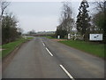
Castlethorpe Road
Castlethorpe Road heading to Castlethorpe passing Malt Mill Farm
Image: © Shaun Ferguson
Taken: 17 Feb 2011
0.24 miles
7
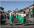
Ladies Morris
A ladies Morris Dancing side, at the street fair, Hanslope
Image: © George Mahoney
Taken: 13 Sep 2003
0.24 miles