IMAGES TAKEN NEAR TO
Mill View, Station Road, MILTON KEYNES, MK19 7HE
Introduction
This page details the photographs taken nearby to Mill View, Station Road, MK19 7HE by members of the Geograph project.
The Geograph project started in 2005 with the aim of publishing, organising and preserving representative images for every square kilometre of Great Britain, Ireland and the Isle of Man.

There are currently over 7.5m images from over14,400 individuals and you can help contribute to the project by visiting https://www.geograph.org.uk
Image Map
Images are licensed for reuse under creativecommons.org/licenses/by-sa/2.0
Notes
- Clicking on the map will re-center to the selected point.
- The higher the marker number, the further away the image location is from the centre of the postcode.
Image Listing (42 Images Found)
Images are licensed for reuse under creativecommons.org/licenses/by-sa/2.0
Image
Details
Distance
1
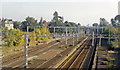
Site of Castlethorpe station, West Coast Main Line, 1991
View SE, towards Bletchley and London: ex-LNWR WCML. Hardly a trace of the station, which was closed from 7/9/64, prior to the electrification in 1966.
Image: © Ben Brooksbank
Taken: 13 Oct 1991
0.02 miles
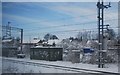
2
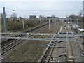
West Coast Main Line
West Coast Main Line at the site of the former Castlethorpe station
Image: © Shaun Ferguson
Taken: 17 Feb 2011
0.03 miles
3
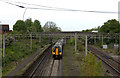
Site of Castlethorpe station
Closed in 1964 but the platforms still visible. A London Midland 350 unit passes on its way to London Euston
Image: © Robert Eva
Taken: 8 May 2017
0.04 miles
4
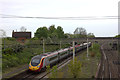
Remains of Castlethorpe station with northbound Pendolino
Image: © Robert Eva
Taken: 8 May 2017
0.06 miles
5
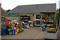
Castlethorpe village shop
A lot more stock outside than 5 years ago. The post box does not look like it has been painted since then.
Image: © Robert Eva
Taken: 8 May 2017
0.06 miles
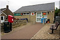
7
Castlethorpe. Green at the junction of Station Rd and North St
Image: © Robert Eva
Taken: 8 May 2017
0.08 miles
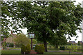
8
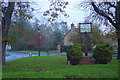
Top of Station Road, Castlethorpe
There is a grassy triangle where Station Road, North Street and Hanslope Road meet on the edge of Castlethorpe village. The space has been used for a village sign depicting the church.
Image: © Stephen McKay
Taken: 16 Nov 2019
0.08 miles
9
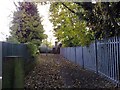
Path to Footbridge, Castlethorpe
Path leading to a footbridge over the West Coast Main Line near the former station at Castlethorpe.
Image: © mick finn
Taken: 8 Nov 2008
0.08 miles
10
West Coast Main Line passes through Castlethorpe
Image: © N Chadwick
Taken: 19 Dec 2010
0.08 miles