IMAGES TAKEN NEAR TO
Carrington Grove, MK19 7GF
Introduction
This page details the photographs taken nearby to Carrington Grove, MK19 7GF by members of the Geograph project.
The Geograph project started in 2005 with the aim of publishing, organising and preserving representative images for every square kilometre of Great Britain, Ireland and the Isle of Man.

There are currently over 7.5m images from over14,400 individuals and you can help contribute to the project by visiting https://www.geograph.org.uk
Image Map (Loading...)


Getting Data...Please wait
Leaflet Map data © OpenStreetMap
Images are licensed for reuse under creativecommons.org/licenses/by-sa/2.0
Notes
- Clicking on the map will re-center to the selected point.
- The higher the marker number, the further away the image location is from the centre of the postcode.
Image Listing (49 Images Found)
Images are licensed for reuse under creativecommons.org/licenses/by-sa/2.0
Image
Details
Distance
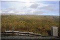
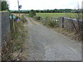
2
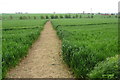
Path from Haversham approaching Castlethorpe
Image: © Robert Eva
Taken: 8 May 2017
0.06 miles
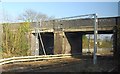
4
Cycle route 6 bridge over the railway near Castlethorpe
Image: © Robert Eva
Taken: 8 May 2017
0.07 miles
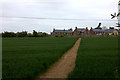
6
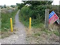
NCN route 6
Start of a stretch of route 6 alongside the West Coast Mainline
Image: © Richard Croft
Taken: 7 Aug 2014
0.09 miles
7
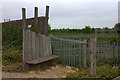
Seat by the railway bridge near Castlethorpe
Similar seats can be seen along the cycle route into Wolverton
Image: © Robert Eva
Taken: 8 May 2017
0.10 miles
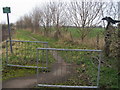
9
Fox Covert Lane
NCN route 6 on Fox Covert Lane near Castlethorpe
Image: © Richard Croft
Taken: 7 Aug 2014
0.12 miles
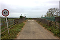
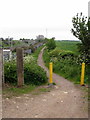
10
National cycle route No 6
National cycle route No 6 leaves Wolverton Road near Castlethorpe
Image: © Shaun Ferguson
Taken: 17 Feb 2011
0.12 miles