IMAGES TAKEN NEAR TO
Castlethorpe, MILTON KEYNES, MK19 7ET
Introduction
This page details the photographs taken nearby to MK19 7ET by members of the Geograph project.
The Geograph project started in 2005 with the aim of publishing, organising and preserving representative images for every square kilometre of Great Britain, Ireland and the Isle of Man.

There are currently over 7.5m images from over14,400 individuals and you can help contribute to the project by visiting https://www.geograph.org.uk
Image Map
Images are licensed for reuse under creativecommons.org/licenses/by-sa/2.0
Notes
- Clicking on the map will re-center to the selected point.
- The higher the marker number, the further away the image location is from the centre of the postcode.
Image Listing (5 Images Found)
Images are licensed for reuse under creativecommons.org/licenses/by-sa/2.0
Image
Details
Distance
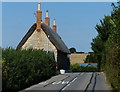
2
Bus heading along Wolverton Road
The bus is passing Lodge Cottages on the way towards the village of Castlethorpe.
Image: © Mat Fascione
Taken: 8 Aug 2015
0.18 miles
3
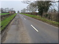
Wolverton Road
Wolverton Road heading to Caslethorpe by the footpath to Leamington Farm
Image: © Shaun Ferguson
Taken: 17 Feb 2011
0.19 miles
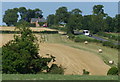
5
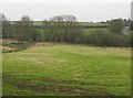
Brook and Fields
Located close the Northern boundary of Milton Keynes, this is still unspoilt countryside and the Brook (or small stream) can be seen to the left of frame. The road leaves to Haversham (and Milton Keynes).
Image: © Richard Thomas
Taken: 26 Dec 2006
0.25 miles