IMAGES TAKEN NEAR TO
Maltings Field, MILTON KEYNES, MK19 7EG
Introduction
This page details the photographs taken nearby to Maltings Field, MK19 7EG by members of the Geograph project.
The Geograph project started in 2005 with the aim of publishing, organising and preserving representative images for every square kilometre of Great Britain, Ireland and the Isle of Man.

There are currently over 7.5m images from over14,400 individuals and you can help contribute to the project by visiting https://www.geograph.org.uk
Image Map
Images are licensed for reuse under creativecommons.org/licenses/by-sa/2.0
Notes
- Clicking on the map will re-center to the selected point.
- The higher the marker number, the further away the image location is from the centre of the postcode.
Image Listing (53 Images Found)
Images are licensed for reuse under creativecommons.org/licenses/by-sa/2.0
Image
Details
Distance
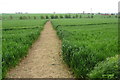
3
Path from Haversham approaching Castlethorpe
Image: © Robert Eva
Taken: 8 May 2017
0.10 miles
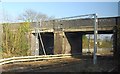
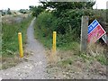
4
Cycle route 6 bridge over the railway near Castlethorpe
Image: © Robert Eva
Taken: 8 May 2017
0.11 miles
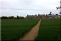
6
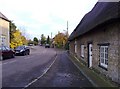
South Street. Castlethorpe
Viewed from near the disused railway station.
Image: © mick finn
Taken: 8 Nov 2008
0.12 miles
7
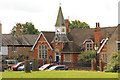
Castlethorpe First School
Village school on North Street in Castlethorpe, opened by Lord Carrington on 15th October 1891 and still going strong.
Image: © Richard Croft
Taken: 7 Aug 2014
0.12 miles
8
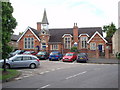
Castlethorpe School
The infant school in the village of Castlethorpe.
Image: © Richard Schmidt
Taken: 20 May 2007
0.12 miles
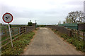
9
NCN route 6
Start of a stretch of route 6 alongside the West Coast Mainline
Image: © Richard Croft
Taken: 7 Aug 2014
0.12 miles
10
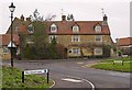
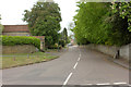
Castlethorpe
The East end of the Village of Castlethorpe at the junction of Wolverton Road and Bullington End Road.
Image: © Richard Thomas
Taken: 26 Dec 2006
0.13 miles