IMAGES TAKEN NEAR TO
Bullington End, MILTON KEYNES, MK19 7BQ
Introduction
This page details the photographs taken nearby to Bullington End, MK19 7BQ by members of the Geograph project.
The Geograph project started in 2005 with the aim of publishing, organising and preserving representative images for every square kilometre of Great Britain, Ireland and the Isle of Man.

There are currently over 7.5m images from over14,400 individuals and you can help contribute to the project by visiting https://www.geograph.org.uk
Image Map
Images are licensed for reuse under creativecommons.org/licenses/by-sa/2.0
Notes
- Clicking on the map will re-center to the selected point.
- The higher the marker number, the further away the image location is from the centre of the postcode.
Image Listing (8 Images Found)
Images are licensed for reuse under creativecommons.org/licenses/by-sa/2.0
Image
Details
Distance
2
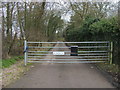
Gated drive to New Buildings Farm
Footpath and gated drive to New Buildings Farm
Image: © Shaun Ferguson
Taken: 17 Feb 2011
0.07 miles
3
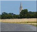
The Church of St James the Great in Hanslope
Viewed from the driveway of Manor Farm, this is the tallest church spire in Buckinghamshire, at 186 feet (57 m).
Image: © Mat Fascione
Taken: 8 Aug 2015
0.10 miles
4
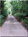
Bridleway and track to New Buildings Farm
Image: © Philip Jeffrey
Taken: 10 Sep 2012
0.11 miles
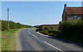
5
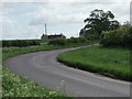
Bend in the Road
The road from Castlethorpe to Hanslope.
Image: © Richard Schmidt
Taken: 19 May 2007
0.11 miles
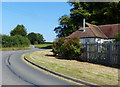
6

Hatton Court Hotel
Or at least it used to be
Image: © Philip Jeffrey
Taken: 3 Mar 2012
0.12 miles
7
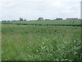
Farmland
The view across fields to Manor Farm, near Hanslope.
Image: © Richard Schmidt
Taken: 19 May 2007
0.24 miles