IMAGES TAKEN NEAR TO
Park Road, MILTON KEYNES, MK19 7BJ
Introduction
This page details the photographs taken nearby to Park Road, MK19 7BJ by members of the Geograph project.
The Geograph project started in 2005 with the aim of publishing, organising and preserving representative images for every square kilometre of Great Britain, Ireland and the Isle of Man.

There are currently over 7.5m images from over14,400 individuals and you can help contribute to the project by visiting https://www.geograph.org.uk
Image Map
Images are licensed for reuse under creativecommons.org/licenses/by-sa/2.0
Notes
- Clicking on the map will re-center to the selected point.
- The higher the marker number, the further away the image location is from the centre of the postcode.
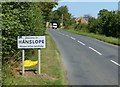
Image Listing (3 Images Found)
Images are licensed for reuse under creativecommons.org/licenses/by-sa/2.0
Image
Details
Distance
1
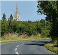
Park Road heading towards Hanslope
Looking towards the Church of St James the Great in Hanslope, it is the tallest church spire in Buckinghamshire, at 186 feet (57 m).
Image: © Mat Fascione
Taken: 8 Aug 2015
0.06 miles
3
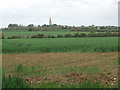
Rural View
The view across the fields with Hanslope village in the background.
Image: © Richard Schmidt
Taken: 19 May 2007
0.21 miles