IMAGES TAKEN NEAR TO
Northampton Road, MILTON KEYNES, MK19 7BB
Introduction
This page details the photographs taken nearby to Northampton Road, MK19 7BB by members of the Geograph project.
The Geograph project started in 2005 with the aim of publishing, organising and preserving representative images for every square kilometre of Great Britain, Ireland and the Isle of Man.

There are currently over 7.5m images from over14,400 individuals and you can help contribute to the project by visiting https://www.geograph.org.uk
Image Map
Images are licensed for reuse under creativecommons.org/licenses/by-sa/2.0
Notes
- Clicking on the map will re-center to the selected point.
- The higher the marker number, the further away the image location is from the centre of the postcode.
Image Listing (6 Images Found)
Images are licensed for reuse under creativecommons.org/licenses/by-sa/2.0
Image
Details
Distance
3
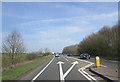
A508 approaches junction with Northampton Road
Image: © Stuart Logan
Taken: 29 Mar 2014
0.11 miles
5
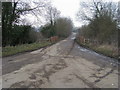
Old Cosgrove Road across Dogsmouth Bridge
Off Stratford Road access route old Cosgrove Road across Dogsmouth Bridge
Image: © Shaun Ferguson
Taken: 17 Feb 2011
0.12 miles
6
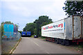
Truck Protest, Cosgrove Road
Cosgrove Road is now a quiet dead end, cut through by the A5. Development plans for warehouses are being opposed.
Image: © Des Blenkinsopp
Taken: 28 Jun 2023
0.23 miles